Groundwater is one of Missouri’s most vital natural resources. Missouri occupies an area of about 69,709 square miles, and the geologic conditions across the state vary greatly. The state’s geology is composed mostly of sedimentary rocks like sandstone and fractured limestone and dolomite. These strata serve as substantial groundwater reservoirs. Because of this, much of Missouri contains an abundance of fresh, drinkable groundwater available for use.
Missouri's groundwater resources are tied closely to the geology of the various regions and also varies greatly across the state. There are more than a dozen major aquifers underlying various parts of the state. In some areas, three or more aquifers are present. In other areas where groundwater resources are poor, there may only be one aquifer or none at all.
Missouri Groundwater Provinces
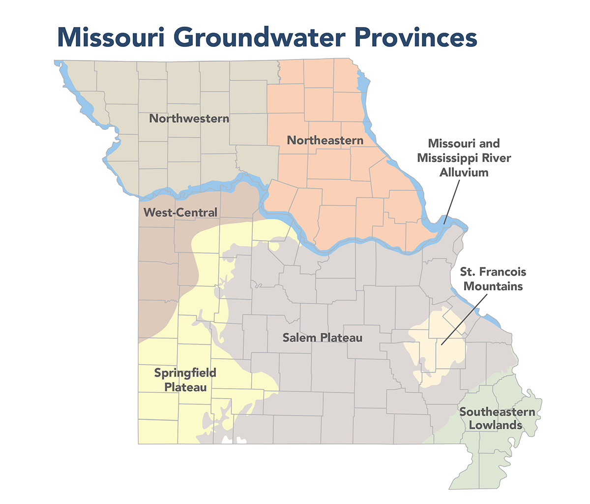
Nearly all of the geologic formations in Missouri are capable of storing and discharging varying amounts of groundwater. However, not all of the units yield water in sufficient amounts to be considered important aquifers. Because of these differences in geologic conditions, Missouri has been divided into eight major groundwater provinces.
- Mississippi and Missouri River Alluvium Groundwater Province - PUB2997
- Northeast Missouri Groundwater Province - PUB2998
- Northwest Missouri Groundwater Province - PUB2999
- St. Francois Mountains Groundwater Province - PUB3003
- Salem Plateau Groundwater Province - PUB3000
- Southeastern Lowlands Groundwater Province - PUB3001
- Springfield Plateau Groundwater Province - PUB3002
- West-Central Missouri Groundwater Province - PUB3004
The groundwater province boundaries do not represent groundwater divides. The boundaries are drawn based on several factors, including aquifer characteristics, groundwater quality changes and aquifer boundaries. Aquifers, and thus local and regional groundwater flows, can and do cross the various groundwater provinces. Access the Groundwater Observation Well Network for near real-time data.
Groundwater Availability
Groundwater resources in Missouri are not evenly distributed. The amount of usable groundwater is far less in northern Missouri where only about 12% of Missouri's potable groundwater is found. The largest, most extensive aquifer is the Ozark Aquifer in the Salem and Springfield Plateau groundwater provinces.
The distinction between an important aquifer and one which is not is often subjective, and to a great extent depends on location and perspective. A rural resident living in northwestern Missouri might be pleased to have a well that yields one to three gallons per minute (gpm). Since groundwater resources are generally poor in this area, and yields greater than this are uncommon, such a yield would be considered good by local standards. Another person living in central Missouri, where well yields are generally better, would likely be disappointed if his well yielded less than 15 gpm. For an irrigation system, public water supply, or an industry requiring substantial water, any quantity less than several hundred gallons per minute may not be considered significant.
Aquifers can be classified into two general types, unconfined aquifers and confined aquifers. In an unconfined aquifer, the water table forms the upper boundary of the aquifer. The water table is the surface between the unsaturated materials above the water table and the saturated materials below. The water level in a well drilled into an unconfined aquifer is the water table. A confined aquifer is bounded above and below by confining beds that have much lower permeabilities than the aquifer.
The water level in a tightly cased well drilled into a confined aquifer will usually be some distance above the top of the aquifer due to the head pressure on the water in the aquifer. If the water level in the well rises above land surface, it is termed a flowing artesian well.
Aquifers are often named after the geologic formation that comprises them. Examples of this include the St. Peter Sandstone, the Missouri River alluvium, and the McNairy Formation. However, unless the specific geologic formation is hydrologically isolated from the units above and below it, it is generally best not to name the aquifer after the geologic unit. In Missouri, several geologic formations commonly comprise a single aquifer.
Water termed “fresh” or “potable” refers to water containing less than 1,000 milligrams per liter (mg/L) of total dissolved solids, and less than 250 mg/L each of sulfate and chloride. These criteria are based, in part, on secondary water-quality standards used by the department for public water supplies. Aquifers that contain potable water in the Ozarks generally contain highly mineralized water in other places. Thus, the total volume of groundwater in storage statewide is somewhat greater than the volume of freshwater available to Missourians.
In many areas of Missouri, the deep aquifer zones contain water that is of poor quality. In Missouri a natural feature known as the freshwater-saline water transition zone runs from approximately Joplin to Warrensburg, to Mexico to Troy to Festus. Groundwater contained in deeper aquifer zones south of the transition zone generally contains less than 1,000 mg/L total dissolved solids, and less than 250 mg/L of chloride and sulfate, and is generally potable without treatment. North of the transition zone, groundwater in the same aquifer zones becomes increasingly mineralized and contains excessive total dissolved solids and chloride, and may contain excessive sulfate which makes the water unpotable.