
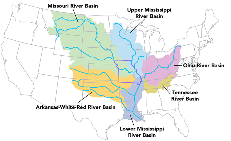
Interstate waters are streams, rivers, lakes and other surface water bodies that form part of a state border or flow through or are shared by two or more U.S. states. Missouri is located in the center of the United States. We not only share water with the eight states along our border, we share water with a total of 26 other states (as either an upstream or downstream state) and two Canadian provinces.
In Missouri, interstate waters include the Mississippi, Missouri and White rivers and their basins. A river basin is a large area of land drained by a major river and all of its branches, or tributaries. Rivers may be used as political boundaries, as in the case of the Mississippi River that forms the natural boarder between Missouri and Illinois. However, basin boundaries, or divides, have no respect for state lines. Therefore, river basin boundaries are recognized in dealing with interstate water issues.
In calculating the water resources Missouri citizens have a right to use and enjoy, we use river basins as convenient planning units. It is in this context that Missouri lays claim to a fair share of water that flows – for example – from the hot springs of Yellowstone National Park into Yellowstone River, which flows into the Missouri River near Williston, North Dakota. In like manner, Missourians share part of the waters of Lake Itasca, the source of the Mississippi River.
To ensure Missouri's interests are considered, the Missouri Department of Natural Resources represents Missouri on water resource issues that cross political boundaries. The department coordinates issues relating to major river basins that affect Missouri, and provides technical support for negotiations and litigation actions to protect the state’s rights to this water.
Mississippi River
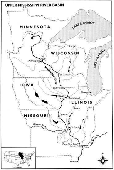
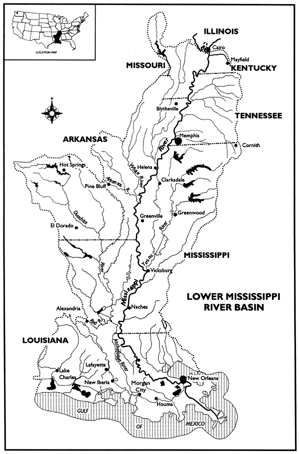
The Mississippi River is the natural border and physical boundary between Missouri and Illinois, Kentucky and Tennessee. The Mississippi River is traditionally separated into two sections. The Upper Mississippi River separates eastern Missouri from western Illinois for 361 miles to the Ohio River confluence near Cairo, Illinois. The Lower Mississippi River separates southeastern Missouri from Kentucky and Tennessee for 126 miles.
The Mississippi River basin is the largest drainage basin in the United States, third largest in the world according to the US Army Corps of Engineers. The Upper Mississippi River basin encompasses the headwaters in Minnesota and Wisconsin to the Ohio River confluence near Cairo, Illinois. The Lower Mississippi River basin includes the area from the Ohio River confluence, south to the Gulf of Mexico. In total, the basin includes all or parts of 31 states and two Canadian provinces.
The Mississippi River is an important waterway. Barges transport goods to both domestic and foreign markets. Upstream of St. Louis, a series of locks and dams maintain adequate water depths for navigation. Downstream of St. Louis, the Mississippi River is free flowing all the way to the Gulf of Mexico. The Mississippi River also provides an important source of water for drinking, cooling, recreation, and fish and wildlife.
River Data
- Real-Time Stream Flows - U.S. Geological Survey
- Mississippi River Basin Forecasts - National Weather Service (NOAA)
- Lower Mississippi River Observations and Forecasts - National Weather Service (NOAA)
Associations and Groups
- Upper Mississippi River Basin Association
- Lower Mississippi River Conservation Committee
- Mississippi River Commission
Studies and Projects
- Gulf Hypoxia Program
- Mississippi River Chlordane and PCB Total Maximum Daily Load
- Mississippi River Metals Total Maximum Daily Load
- Upper Mississippi Environmental Management Program - US Army Corps of Engineers
- Upper Mississippi Comprehensive Plan - US Army Corps of Engineers
- Upper Mississippi River Spill Response Plan and Resource Manual
- Upper Mississippi River Restoration Program: Long Term Resource Monitoring - U.S. Geological Survey
Missouri River
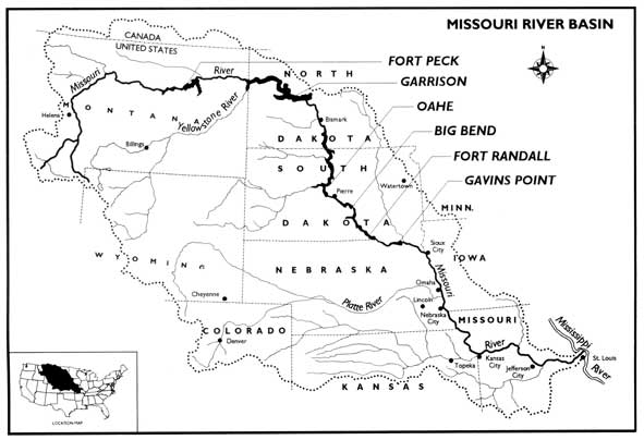
The Missouri River is the longest river in the United States. It crosses or borders seven states, stretching over 2,300 miles from southwestern Montana to just north of St. Louis, Missouri, where it joins the Mississippi River. The Missouri River flows approximately 553 miles through upper central Missouri, dividing several major metropolitan areas. It earned the nickname "The Big Muddy", due to its heavy silt and muddy brown color.
From the 1930s to the 1960s, six dams were built on the Missouri River, creating the largest reservoir system in the United States. The Missouri River Reservoir System has the capacity to store approximately 73 million acre-feet of water (one acre-foot of water is equivalent to 325,851 gallons of water). The majority of this water is stored in the upper three reservoirs in Montana, North Dakota and South Dakota.
More than half of all Missourians receive their drinking water from the Missouri River and its alluvium. Missouri's interest in the river also includes recreation, power generation, water supply, river commerce, and fish and wildlife.
River Data
- Missouri River Reservoir Control Center - US Army Corps of Engineers
- Missouri River Basin Water Management Daily River Bulletin - US Army Corps of Engineers
- Missouri River Main Stem and Major Tributary DCP Data - US Army Corps of Engineers - reservoir storage, inflow, outflow and discharge, temperature reading at the mainstem reservoirs
- Missouri Basin River Forecast Center - National Weather Service
- Real-Time River Information - National Weather Service - Current and forecasted river stage information for 16 locations along the Missouri River from St. Joseph to St. Charles.
Associations and Groups
- Friends of the Big Muddy
- Missouri River Coalition
- Missouri River Recovery Implementation Committee (MRRIC)
- Missouri River Relief
Studies and Projects
- Lower Missouri River Flood Resiliency Studies
- Lower Missouri River Navigation - US Army Corps of Engineers
- Missouri River 2003 Amended Biological Opinion - U.S. Fish and Wildlife Service - 2003 Amendment to the 2000 Biological Opinion on the Operation of the Missouri River Main Stem Reservoir System, Operation and Maintenance of the Missouri River Bank Stabilization and Navigation Project, and Operation of the Kansas River Reservoir System.
- Missouri River Authorized Purposes Study, May 2010 - US Army Corps of Engineers
- Missouri River Bed Degradation Feasibility Study - US Army Corps of Engineers
- Missouri River Chlordane and Polychlorinated Biphenyls Total Maximum Daily Loads
- Missouri River Flood Task Force - US Army Corps of Engineers
- Missouri River Master Water Control Manual, November 2018 - US Army Corps of Engineers
- Missouri River Planning: Recognizing and Incorporating Sediment, 2011 - National Academies
- Missouri River Recovery Program - US Army Corps of Engineers
- Missouri River Recovery Program Science and Adaptive Management Plan, August 2018 - US Army Corps of Engineers
- Missouri Water...In High Demand - Missouri Resources Magazine Winter 2006
- US Army Corps of Engineers Recreation Operational Status
White River
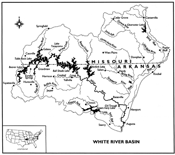
The White River runs approximately 720 miles from southern Missouri, through the Ozark Mountains, downward to the streams of northern Arkansas. Headwaters in the alluvial valley section of the Gulf Coastal Plain province in southeast Missouri and northeast Arkansas also carry abundant flow to the White River. Headwaters originating from the Ozark Plateau province of the White River are renowned for their aesthetic value as well as recreational desirability.
A variety of uses are seen on the White River including recreation, municipal and industrial water supply, fish and wildlife as well as power generation. Clear, cool water flowing form the karst topography of the Ozark mountains form streams popular for tourists and recreationists from throughout the midwestern United States and beyond, creating a major economic benefit to the region. Abundant streamflow and deep, narrow valleys create ideal settings for hydroelectric power generation from dams of the major reservoirs. As a result of the large reservoirs in the region, lake recreation has also become popular and a major contributor to economic growth. White River is internationally know for world-class trout fishing below dams like Bull Shoals Dam. Agricultural irrigation is a major use of those waters along with fish and wildlife, as well as riverine and backwater recreation.
River Data
- White River Entrance Channel Long Range Forecast - US Army Corps of Engineers
- White River Basin Forecasts - National Seather Service