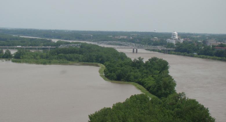
An image showing Missouri River flooding in the vicinity of Jefferson City, Missouri.


The Lower Missouri River experienced three devastating floods within 30 years: 1993, 2011 and 2019. Over the past decade the Lower Missouri River Basin has experienced unprecedented periods of flooding and recorded its first, second and fourth highest runoff years. The 2019 flood caused billions of dollars in damages to agriculture and infrastructure for communities in Iowa, Nebraska, Kansas and Missouri. Repair costs to levee infrastructure in the lower river was approximately $1.2 billion.

During the 2019 flood, Missouri, Kansas, Iowa and Nebraska formed a four-state coalition called the Flood Recovery Advisory Working Group. The states entered into a Memorandum of Agreement to cooperatively explore innovative solutions to improve flood protection. The goal was to develop actions to improve flood recovery and future flood control in the Lower Missouri River Basin and improve coordination and cooperation between the states and the U.S. Army Corps of Engineers.

Progress

As part of this effort, the group coordinated in 2020 and 2021 to conduct the Lower Missouri River Flood Risk and Resiliency Study, or System Plan. This plan will create a roadmap for the broader Lower Missouri River, from Sioux City, Iowa to St. Louis, Missouri. There are also three studies currently underway in Missouri investigating flood control systems along the Missouri River in Holt County, Brunswick and Jefferson City. These "spin-off" studies are in priority flood risk areas and provide a more in-depth look at the areas to formulate local, problem-specific solutions to address flood risks. By starting the feasibility study before completing the system plan, project areas with approved feasibility reports can seamlessly progress into the design phase. More project areas may be included as the system plan progresses. More information on all of these studies is available below.

In support of this historic effort, USACE is conducting updates to the Flow and Stage Frequencies on the lower river. The flow frequency analysis calculates the annual probability that a flow will be met or exceeded at a specific location. This data provides accurate tools for directing future study, action and planning for flood risk management in the Lower Missouri River Basin. The Flow Frequency Report was finalized in October 2023 and the Stage Frequency analysis has begun. Stage frequency analysis and reviews will take approximately two years. For more information, or to review the report, please visit the USACE's Flow and Stage Frequency Analysis webpage.

We Want to Hear from You

The flood protection methods of the Missouri River studies are being considered as part of a community-based approach. It is essential that residents in the study areas communicate their questions and concerns. Please send any comments, questions or other feedback to mowaters@dnr.mo.gov. If you would like to be added to our email notification list, please use the the green "Get Updates on this Issue" button.

System Plan

Section 216 of the Water Resources Development Act of 2020 authorized the expansion of an initial feasibility study to a broader lower basin effort. The system evaluation is for over 735 Missouri River miles from Sioux City, Iowa, to the mouth near St. Louis, Missouri. In partnership with Missouri, Kansas, Iowa and Nebraska; the study will coordinate with basin states, tribes, stakeholders, levee districts, other agencies and the public to create a vision for a more resilient future for the Lower Missouri River, with a focus on flood risk management. Outcomes of the study will include system analysis providing context to the initial spin-off studies, identify and recommend any additional spin-off feasibility studies and their locations, identify potential policy recommendations that would support the system and potential actions for local stakeholders. 

Timeline 

An Interim System Plan Report is due to be completed and submitted to Congress December 2023. The study’s final completion date is March 2027. 

Upcoming Meetings

Links to upcoming meetings can be found on USACE's Lower Missouri River Basin Flood Risk & Resiliency Study webpage.

Past Meetings

Brunswick Study

The purpose of the Brunswick Study is to identify causes and impacts of recurring flooding along the Missouri River Levee System (MRLS) L-246 and near the city of Brunswick, Missouri. The study area is generally along the left bank of the Missouri River bordering the Grand and Chariton rivers. This area includes the City of Brunswick and behind MRLS L-246 within Chariton County, Missouri. For more information, please visit USACE's Brunswick, MO / L246 webpage.

Upcoming Meetings

  • There are no upcoming meetings currently planned. Please check back often for more information.

Past Meetings

Holt County Study

The purpose of the Holt County Study is to investigate methods to reduce and manage flood risk within the project area by evaluating measures, recommending a plan to reduce recurring infrastructure damages, and improve resiliency to protect future investments. The study area includes the floodplain along 50 miles of the Missouri River from Nishnabotna to St. Joseph, Missouri. Federal levees in and around the project area include 512-513R-North, Missouri River Levee System (MRLS) 497-L, MRLS 488-L and MRLS 500-R. Non-Federal levee systems include Union Township Holt County Number 10, Holt County Number 9, Canon Drainage District and Kimsey Holley. For more information, please visit USACE's Holt County, MO / Doniphan County, KS webpage.

Upcoming Meetings

  • There are no upcoming meetings currently planned. Please check back often for more information.

Past Meetings 

Jefferson City Study

The purpose of the Jefferson City Study is to identify causes and impacts of recurring flooding along Capital View Levee and the unconstructed, but authorized, Missouri River Levee System (MRLS) L-142 project in Callaway County near Jefferson City, Missouri. The study area includes the north (or left) bank of the Missouri River in the vicinity of mile marker 142 near Jefferson City, Missouri. For more information, please visit USACE's Jefferson City, MO / L142 webpage.

Upcoming Meetings

Past Meetings 

Nemaha/ Atchison Study

Information will be coming soon.