

Soil moisture and temperature greatly affect the physical, chemical and biological processes in soil and vegetation. Soil data helps us understand the potential for water storage and movement within the soil. Soil moisture content at the time of a rain event strongly influences whether the water will soak into the soil or run off the surface. Soil temperature is also important for monitoring the potential for water runoff when surface soil is frozen.
The need for additional real-time soil data is specified in the 2020 Missouri Water Resources Plan and the 2023 Missouri Drought Mitigation and Response Plan. Information from a statewide monitoring network would help predict droughts and flooding, agricultural needs, water supply monitoring, forest fire prediction and other natural resource activities.
The department’s Soil Monitoring and Mapping Initiative involves two distinct projects: Soil and Atmospheric Monitoring project and Soil Moisture Mapping project.
Soil and Atmospheric Monitoring Project
The Soil and Atmospheric Monitoring project aims to expand soil moisture and temperature monitoring across Missouri. This involves long-term soil monitoring by installing soil sensors alongside groundwater observation wells and weather stations. The statewide soil monitoring network will consist of stations operated by various state and federal entities.
To help make the soil data more meaningful, most of the monitoring stations will also measure atmospheric variables, such as air temperature, wind speed and direction, relative humidity, solar radiation and precipitation. While not every weather station across Missouri is suitable for soil monitoring, the department will strive to have every soil monitoring site function as a ‘total water station’ by also collecting atmospheric variables.
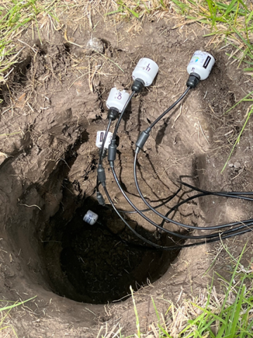
Since 2020, soil sensors have been placed at several groundwater-level monitoring stations maintained by the department’s Water Resources Center. At each station, five probes were placed in ground at depths of 2, 4, 8, 20 and 40 inches. Soil moisture and temperature data are collected every 30 minutes and transmitted every hour by satellite.
The department is currently conducting soil monitoring in the following counties: Atchison, Barry, Barton, Benton, Buchanan, Callaway, Cape Girardeau, Chariton, Christian, Daviess, Jackson, Jefferson, Laclede, Newton, Pemiscot, Perry, Pettis, Ripley, Saline, Scotland, St Louis, and Warren. Soil moisture and groundwater-level data, along with precipitation data (where available), are available in near real-time to the public in the department's Groundwater Observation Wells map viewer. To view only the sites with moisture data, change the "Soil Moisture Sensors" filter field to "Yes."
Soil Moisture Mapping Project
The Soil Moisture Mapping project will use the data collected from each monitoring station to develop gridded, statewide soil moisture and temperature maps. The mapping methodology will likely combine station data and modeling to interpolate soil moisture content, plant available water and soil temperature at several depths.