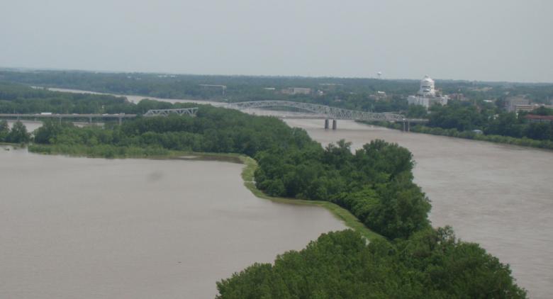
An image showing Missouri River flooding in the vicinity of Jefferson City, Missouri.


Over the past decade the Lower Missouri River Basin has experienced unprecedented durations of flooding and recorded its first, second and fourth highest runoff years. Missouri, Kansas, Iowa and Nebraska agreed in 2019 to work with the U.S. Army Corps of Engineers to cooperatively explore innovative solutions to improve flood protection. Three studies are currently underway in Missouri investigating flood control systems along the Missouri River in Holt County, near Brunswick and near Jefferson City.

We Want to Hear from You 

The flood protection methods of the Missouri River studies are being considered as part of a community-based approach. It is essential that residents in the study areas communicate their questions and concerns. Please send any comments, inquiries or other feedback to mowaters@dnr.mo.gov You can also ask to receive updates for the three Lower Missouri River studies. 

System Plan Study

Background 

The Lower Missouri River sustained three devastating floods within 30 years: 1993, 2011 and 2019. The 2019 flood caused billions of dollars in damages to agriculture and infrastructure for communities in Iowa, Nebraska, Kansas and Missouri. Repair costs to levee infrastructure in the lower river in 2019 was approximately $1.2 billion. During the 2019 flood, Missouri, Kansas, Iowa and Nebraska formed a four-state coalition called the Flood Recovery Advisory Working Group. The goal was to develop actions in the aftermath of the 2019 flood to reduce system risk and recurring damages, improve system resiliency for the future and improve interagency collaboration.
Section 216 of the Water Resources Development Act of 2020 authorized the expansion of an initial feasibility study to a broader lower basin effort. The system evaluation is for over 735 Missouri River miles from Sioux City, Iowa, to the mouth near St. Louis, Missouri. In partnership with Missouri, Kansas, Iowa and Nebraska; the study will coordinate with basin states, tribes, stakeholders, levee districts, other agencies and the public to create a vision for a more resilient future for the Lower Missouri River, with a focus on flood risk management. Outcomes of the study will include system analysis providing context to the initial spin-off studies, identify and recommend any additional spin-off feasibility studies and their locations, identify potential policy recommendations that would support the system and potential actions for local stakeholders. 

Timeline 

An Interim System Plan Report is due to be completed and submitted to Congress December 2023. The study’s final completion date is March 2027. 

Upcoming Meetings

Past Meetings

  • Jan. 17, 2024: Lower Missouri River Studies (or All Things LoMo) Stakeholder Update 
  • Oct. 18, 2023: Lower Missouri River Studies (or All Things LoMo) Stakeholder Update 
  • July 20, 2023: Public Scoping Meeting – Atchison, Kansas
  • July 19, 2023: Public Scoping Meeting – Jefferson City, Missouri
  • July 18, 2023: Public Scoping Meeting – Nebraska City, Nebraska
  • July 17, 2023: Public Scoping Meeting – Council Bluffs, Iowa
  • July 11, 2023: Public Scoping Meeting – Virtual

More Information 

Flow/ Stage Frequency

Background 

The Flow Frequency Analysis Data is a critical update and will inform future study, action and planning for flood risk management in the Lower Missouri River Basin by the U.S. Army Corps of Engineers and Lower Missouri River Studies partners. 

Timeline

The Flow Frequency Report is being finalized and will be uploaded once complete. A webinar on results will occur July 19, 2023. Stage Frequency analysis will then begin, which will help convert flow data measured in cubic feet per second (cfs) to stage data measured as an elevation (ft). Stage frequency analysis and reviews will take approximately two years.

Upcoming Meetings

  • April 17, 2024: Lower Missouri River Studies (or All Things LoMo) Stakeholder Update – Webinar; 12 p.m. CST

Past Meetings

More Information 

Brunswick Study

Background 

Section 216 of the Water Resources Development Act of 2020 authorizes site-specific feasibility studies (spin-off studies) in priority flood risk areas to begin the feasibility study prior to completion of the system plan. This concurrent effort allows for seamless progression into design for project areas with approved feasibility reports. Initial sites in Missouri selected for further evaluation in a spin-off feasibility study include Holt County, Brunswick and Jefferson City. More sites may be determined as the system plan progresses.

Description

The purpose of the Brunswick Study is to identify causes and impacts of recurring flooding along the Missouri River Levee System  (MRLS) L-246 and near city of Brunswick, Missouri.

Location

The study area is generally along the left bank of the Missouri River bordering the Grand and Chariton rivers. This area includes the City of Brunswick and behind MRLS L-246 within Chariton County, Missouri.

Upcoming Meetings

  • 5-7 p.m. Monday, March 11, 2024: Brunswick Spin-Off Study public meeting. Knight and Rucker Banquet Hall, 119 East Broadway Street, Brunswick, Missouri 
  • April 17, 2024: Lower Missouri River Studies (or All Things LoMo) Stakeholder Update – Webinar; 12 p.m. CST

Past Meetings

More Information 

Holt County Study

Background 

Section 216 of the Water Resources Development Act of 2020 authorizes site-specific feasibility studies (spin-off studies) in priority flood risk areas to begin the feasibility study prior to completion of the system plan. This concurrent effort allows for seamless progression into design for project areas with approved feasibility reports. Initial sites selected in Missouri for further evaluation in a spin-off feasibility study include Holt County, Brunswick and Jefferson City. More sites may be determined as the system plan progresses.

Description

The purpose of the Holt County Study is to investigate methods to reduce and manage flood risk within the project area by evaluating measures, recommending a plan to reduce recurring infrastructure damages, and improve resiliency to protect future investments.

Location

The study area includes the floodplain along 50 miles of the Missouri River from Nishnabotna to St. Joseph, Missouri. Federal levees in and around the project area include 512-513R-North, Missouri River Levee System (MRLS) 497-L, MRLS 488-L and MRLS 500-R. Non-Federal levee systems include Union Township Holt County Number 10, Holt County Number 9, Canon Drainage District and Kimsey Holley.

Upcoming Meetings

  • 5-7 p.m. Monday, April 1, 2024: Holt County Spin-Off Study public meeting. Location TBA 
  • April 17, 2024: Lower Missouri River Studies (or All Things LoMo) Stakeholder Update – Webinar; 12 p.m. CST

Past Meetings 

More Information 

Jefferson City Study

Background 

Section 216 of the Water Resources Development Act of 2020 authorizes site-specific feasibility studies (spin-off studies) in priority flood risk areas to begin the feasibility study prior to completion of the system plan. This concurrent effort allows for seamless progression into design for project areas with approved feasibility reports. Initial sites selected in Missouri for further evaluation in a spin-off feasibility study include Holt County, Brunswick and Jefferson City. More sites may be determined as the system plan progresses.

Description

The purpose of the Jefferson City Study is to identify causes and impacts of recurring flooding along Capital View Levee and the unconstructed, but authorized, Missouri River Levee System (MRLS) L-142 project in Callaway County near Jefferson City, Missouri.

Location

The study area includes the north (or left) bank of the Missouri River in the vicinity of mile marker 142 near Jefferson City, Missouri.

Upcoming Meetings

Past Meetings 

More Information