The department coordinates issues relating to major river basins that affect Missouri, and provides technical support for negotiations and litigation actions to protect the state’s rights to this water.

Missouri is located in the center of the United States. We not only share water with the eight states along our border, we share water with a total of 26 other states (as either an upstream or downstream state) and two Canadian provinces. To ensure Missouri's interests are considered, the department represents Missouri on water resource issues that traverse political boundaries. Interstate waters include the Mississippi, Missouri and White rivers and their basins.
A river basin is the total land area drained by a river and all of its tributaries. It is customary to subdivide basins by tributary. For example, the Grand, Osage, Chariton and Gasconade watersheds are sub-basins of the Missouri River basin. In the Mississippi basin, the Missouri, White and Arkansas are sub-basins that drain the various parts of the state of Missouri. The Mississippi is subdivided into the Upper Mississippi and the Lower Mississippi.
Rivers may be used as political boundaries, as in the case of Missouri and Illinois, but basin boundaries, or divides, are not generally used as political boundaries. Therefore, river basins have no respect for state lines. However, river basin boundaries are recognized in dealing with interstate water issues. In calculating the water resources Missouri citizens have a right to use and enjoy, we use river basins as convenient planning units. It is in this context that Missouri lays claim to a fair share of water that flows – for example – from the hot springs of Yellowstone National Park into Yellowstone River, which flows into the Missouri River near Williston, North Dakota. In like manner, Missourians share part of the waters of Lake Itasca, the source of the Mississippi River.
Mississippi River
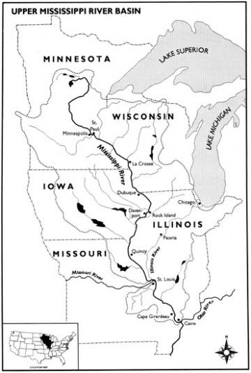
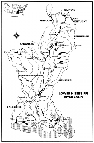
The Mississippi River is the state boundary between Missouri and Illinois along 361 miles of the Upper Mississippi River. For 126 miles the Lower Mississippi River separates Missouri from Kentucky and Tennessee. The Mississippi River is an important waterway, transporting goods to both domestic and foreign markets. Upstream of St. Louis, a series of locks and dams maintain adequate water depths for navigation. Downstream of St. Louis, the Mississippi River is free flowing all the way to the Gulf of Mexico. The Mississippi River also provides an important source of water for drinking, cooling, recreation, and fish and wildlife.
The Ohio River confluence is a dividing line within the Mississippi River basin. The Upper Mississippi River basin encompasses the headwaters in Minnesota and Wisconsin to the confluence near Cairo, Illinois. The Lower Mississippi River basin includes the area below the confluence to the Gulf of Mexico.
River Data
- Real-Time Stream Flows (USGS)
- Upper Mississippi and Illinois River Basin Forecasts (NOAA)
- Lower Mississippi River Basin Forecast (NOAA)
Groundwater Data
- Groundwater Observation Wells (MoDNR ArcGIS application) An excellent source for current information on Missouri's groundwater levels
Associations and Groups
- Upper Mississippi River Basin Association
- Lower Mississippi River Conservation Committee
- Mississippi River Commission
Projects and Studies
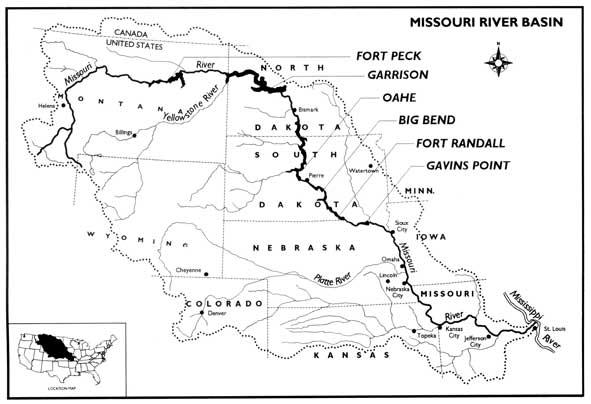
Missouri River
The Missouri River is a vital resource to Missouri. It flows approximately 553 miles through Missouri transecting several major metropolitan areas. More than half of all Missourians receive their drinking water from the river and its alluvium. Missouri's interest in the river also includes recreation, power generation, water supply, river commerce, and fish and wildlife. From the 1930s to the 1960s, six dams were constructed on the Missouri River thereby creating the largest reservoir system in the United States. The Missouri River Reservoir System has the capacity to store approximately 73 million acre-feet of water (one acre-foot of water is equivalent to 325,851 gallons of water). The majority of this water is stored in the upper three reservoirs in Montana, North Dakota and South Dakota.
River Data
- Missouri River Reservoir Control Center (USACE)
- Missouri River Basin Water Management Information Daily River Bulletin (USACE)
- Missouri River daily reservoir levels and releases, river stage and discharge Daily Reservoir Data (USACE)
- Missouri River main stem and tributary reservoir storage, inflow, outflow and discharge Daily Reservoir Temperature Data (USACE) Temperature reading at the mainstem reservoirs (in Fahrenheit)
- Basin Forecasts (NOAA) Morning river stage and up to 5-day forecast along the Missouri River from Sioux City, Iowa to St. Charles, Missouri
- Real-Time River Information (NOAA) Current and forecasted river stage information for 16 locations along the Missouri River from St. Joseph to St. Charles.
- Real-Time Stream Flows (USGS) Near-instantaneous information on Missouri River stage and discharge from MT-MO
Groundwater Data
Groundwater Observation Wells (MoDNR ArcGIS application) An excellent source for current information on Missouri's groundwater levels
Associations and Groups
Projects and Studies
- Missouri River Flood Task Force (USACE) A temporary forum for federal, state, local, and Tribal governments to address issues related to the 2011 Missouri River flooding.
- Missouri River TMDL (MoDNR) Total Maximum Daily Limit (TMDL) for Chlordane and PCB levels in fish taken from the Missouri River. Approved Nov. 3, 2006
- Missouri Resources Winter 2006 (MoDNR) Discussion of Missouri's interest in the Missouri River
- Missouri River Authorized Purposes Study (USACE) Status and information on the study to re-examine the original project purposes of Missouri River basin projects managed by the U.S. Army Corps of Engineers and Bureau of Reclamation, as established in the 1944 Flood Control Act.
- Missouri River Recovery Program (USACE) The Corps main portal to Recovery Program initiatives including, but not limited to, the Missouri River Recovery Implementation Committee (MRRIC) and the Science and Adaptive Management Plan.
- Missouri River Master Manual (USACE) The document by which the U.S. Army Corps of Engineers is to operate the Missouri River mainstem reservoirs
- Missouri River Mitigation (USACE) Access to mitigation sites and activities in Iowa, Kansas, Nebraska and Missouri
- Missouri River Degradation Reconnaissance Study (USACE) The Kansas City District of the U.S. Army Corps of Engineers is conducting a study of the Missouri River bed degradation from Rulo, Nebraska to St. Louis.
- Missouri River Navigation Index Maps (USACE) Links to navigation charts from St. Louis to Ponca, Nebraska
- Missouri River Recovery and Associated Sediment Management Issues (National Research Council) Report from the National Academy of Sciences related to sediment issues in the Missouri River
- Missouri lakes managed by the USACE Includes such lakes as Harry S Truman, Pomme de Terre, Stockton, Smithville and Long Branch reservoirs
- Missouri River 2003 Amended Biological Opinion (USFWS) A document created by the U.S. Fish and Wildlife Service which contains information and suggested alternatives for endangered species affected by the Missouri River mainstem reservoirs, the Missouri River Bank Stabilization and Navigation Project, and the Kansas River reservoir system.
White River
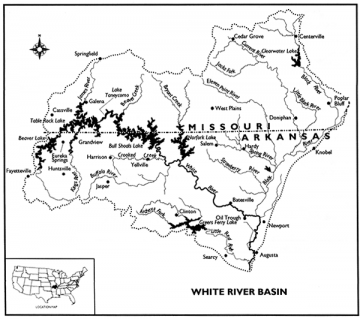
The White River carries water from streams of northern Arkansas and southern Missouri. A variety of uses are seen on the White River including recreation, municipal and industrial water supply, fish and wildlife as well as power generation. Headwaters originating from the Ozark Plateau province of the White River are renowned for their aesthetic value as well as recreational desirability. Clear, cool water flowing form the karst topography of the Ozark mountains form streams popular for tourists and recreationists from throughout the midwestern United States and beyond, creating a major economic benefit to the region. Abundant streamflow and deep, narrow valleys create ideal settings for hydroelectric power generation from dams of the major reservoirs. As a result of the large reservoirs in the region, lake recreation has also become popular and a major contributor to economic growth.
Headwaters in the alluvial valley section of the Gulf Coastal Plain province in southeast Missouri and northeast Arkansas also carry abundant flow to the White River. Agricultural irrigation is a major use of those waters along with fish and wildlife as well as riverine and backwater recreation.
River Data
White River Daily Reports (USACE)
White River Basin Forecasts (NOAA)
Groundwater Data
Groundwater Observation Wells (MoDNR ArcGIS application) An excellent source for current information on Missouri's groundwater levels
Associations and Groups
Arkansas-White-Red Basins Interagency Committee
James River Basin Partnership
Projects and Studies
White River Minimum Flow Study (USACE)