Missouri collects water use data to better understand and manage the state’s water inventory. This data shows what water is being used for (such as municipal, agricultural, hydroelectric, etc.), which regions of the state use the most water, and the demand placed on each source of water (such as an aquifer, lake, or stream). With adequate data, we are able to monitor the health of our water sources and provide data for hydrologic and geologic research. Though the amount of available water can be determined from geology and meteorology, water demand can only be calculated by data provided by Missouri’s major water users.
Am I a Major Water User?
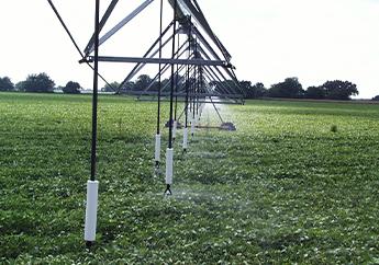
A major water user is any person or entity with the capability of producing 100,000 gallons per day, or approximately 70 gallons per minute, including all wells or surface intakes. This water can be from either groundwater through a well, or surface water via a stream, river, lake, pond or spring.
Reporting
Annual reporting is completed Jan. 1 through March 31 for the previous calendar year. For example, water used between Jan. 1 and Dec. 31, 2024, should be reported between Jan. 1 and March 31, 2025.
Benefits
Why should I care about reporting water use?
So, what's the point of all this? Why does the Missouri Geological Survey and state government need to know how much water I use? Documenting water use data is an activity every state engages in and is normally tied to water permitting and water rights, if applicable to the state.
Missouri is one of only a few states that doesn’t have a water permitting program, so the task falls under the responsibilities of the Water Resources Center. In Missouri, water users have the right to, under most circumstances, use water for whatever purpose they see fit. There is no permit involved, no fees or fines, and no required metering. The only requirement is to report that information to the state the following year if the user has the potential to exceed certain thresholds established by law. The water reporting regulatory framework in Missouri is driven by the state’s access to massive volumes of available water, including the country’s two largest rivers and aquifers containing nearly 500 trillion gallons of potable groundwater.
New scenarios can always require changes in water management. Missouri isn’t immune to issues concerning water supply, legal rights and conservation. Hydrologic data, including water use information, are tools we need to successfully plan for the future. By submitting your water use report, you’re providing Missouri with the data it needs to determine Missouri’s current and future water needs as well as defend the right of Missouri citizens to access Missouri's water sources.
Establishing Missouri's water rights
When it comes to water, Missouri’s position is unique. The nation’s two longest rivers flow through or define Missouri’s borders. These rivers provide drinking water for some of the state’s most populous cities, including St. Louis, Kansas City, Jefferson City, St. Joseph, Cape Girardeau and Hannibal. The river alluvium and floodplains not only serve as excellent farmland, but also contain abundant groundwater for irrigation. Both the Mississippi and the Missouri rivers play direct and critically important roles to a large portion of Missouri’s citizens and economy. The same can also be said for 31 other states, as well as parts of Canada. As climate change and population growth places greater strains on traditional water sources, tributaries of the Mississippi and Missouri rivers are more heavily relied upon, which in turn reduces flow of the rivers downstream. Wells in aquifers are similarly connected, and large withdraws in one well may lower the water table for neighboring wells.
It is more important now than ever to have as much data as possible on Missouri’s water use needs. Freshwater is still abundant to the United States as a whole, but many western states are experiencing water shortages, while water resources in the east are still plentiful, for now. As western states look to other sources of water, it is critical that Missouri establishes its water needs with data and receipts. This is done through the Major Water Use program. It will be very difficult to prove and defend Missouri's needs in court if we do not start collecting this data now. By reporting your data yearly, you are helping protect Missouri’s water rights for generations to come.
Water is a unique resource. It is constantly moving and merging together to create larger bodies. Rain percolates into aquifers, creeks flow into lakes and small streams will merge into powerful rivers. Whatever happens to these smaller water bodies ultimately affects the body into which they are merging. Water, whether it be groundwater or surface water, also does not stop at political boundaries. The result of these two features is that individuals that use small water sources (“upstream users”) can have an effect on users of larger water bodies (“downstream users”) who may be in completely different states or countries. It is easy to see how rights to use water frequently becomes a legal issue.
Securing Water Supply for the Future

Global population is expected to grow to around 11 billion by 2100, meaning food production needs to double from its current rate by 2050. Climate change will likely result in an average temperature global warming, increasing evaporation rates and increasing water needs for cooling. The projections are clear: the world’s water demand will increase and managing our fresh water resources will only grow in importance.
Water use data allows agencies to observe how water use is growing and changing, not just at a state level, but at regional and county levels too. Monitoring these trends, and comparing them to what we see with our stream gage and observation well networks, allows Missouri to plan for the future by identifying potential water supply issues. A great example of this are efforts by local, state and federal agencies providing water to the Springfield and greater southwest Missouri region. Massive population and industry growth in southwest Missouri has strained local aquifers, which the Missouri Geological Survey quickly identified through its observation well network. Water use and census data showed this strain was only likely to increase, so alternative water resources have been identified. The Southwest Missouri Regional Water organization was also formed, and thanks to the efforts of multiple parties at all levels, plans are in place to develop infrastructure that will sustainably pull water from other sources and ensure the security of water resources in the state's southwest region.
Harmonize Our Economy with the Environment
Water plays a critical role in our natural environment, not just for drinking but as a habitat too. There is a growing idea that base needs and “water rights” need to be established to ensure the survival of various ecosystems. For example, fish need a certain threshold of freshwater quantity and quality for their population to be sustainable. If too much of their host stream is withdrawn, the population may die off entirely. Many plant species also rely on a shallow aquifer for their source of water and lowering the water table could have devastating consequences.
Water use data is a vital element in understanding the sustainability of these ecosystems. Without understanding how humans interact with these water sources, it will be extremely difficult to establish how much water can be used before that water limit is reached. Missouri’s economy and environment are thoroughly interconnected. Hunting, fishing, logging and the businesses that compliment them are a multi-billion dollar industry. Camping, boating and lake tourism also provide a large amount of jobs for the state. All of these industries require Missouri’s ecosystems (and water systems) to be healthy, sustainable and thriving.
Misconceptions
Missouri is becoming like other states to the west, where the government tells farmers how much water they can use.
Unlike many of the western states, Missouri has an abundance of water resources and does not have a need to regulate water usage. These resources include, but are not limited to, the Mississippi and Missouri rivers, the Ozark Aquifer, several alluvial aquifers and a large amount of precipitation. As long as these resources are not overstrained, there is no need for regulation or permitting.
If I report my data, the department will start restricting my water use.
There is no legislation enabling the department to restrict water use. All major water users have important needs for their water. The state of Missouri has no plans to limit that use. As long as Missouri’s water sources are not overstrained, there is no need to regulate water use. If you are concerned about future water laws, please contact your state legislator. The General Assembly creates the laws the department is tasked to fulfill and abide by.
I do not need to report because my wells are not metered or I don’t know exactly how much water I use.
Most wells in Missouri are not metered, so exact numbers are nearly impossible to determine. Estimations are acceptable when submitting your report. There will be a place to mark if your values are estimations or exact volumes. You can also contact the Missouri Geological Survey for help in estimating your water usage. Estimated data is better than no data at all.
This is a water permit program.
While major water users must register to submit reports, this is not a permitting program. The Major Water Users Program is established to simply gather water use data. It is not an enforcement or regulation program.
I do not want to pay fees to report my data.
While other states may have fees associated with registering or reporting their water usage, it is absolutely free to report water usage in Missouri. There are no fees or monetary penalties associated with Missouri major water user reporting.
My data will be used to begin taxing my water use.
The Major Water Users Program is operated by the Missouri Geological Survey, who uses the data for scientific, engineering and statistical purposes only. Missouri currently has no intention of taxing water use.
The State Water Plan will prioritize who gets water, and the farmers will be the first to be restricted.
One of the main goals of the Missouri Water Resources Plan is to prepare Missouri for extended droughts. We can identify areas at risk and assist with infrastructure planning to minimize the effects of drought to both the public and agriculture sectors. By reporting your water needs, we can better prepare for the future by understanding the water needs of Missouri’s citizens, industry and municipalities.
How to Register/ Report
The Major Water Use Information System is the preferred method of reporting online. As soon as the major water user has completed the paper or online registration, the process is complete. Registration is a one-time activity required for all major water users, as stated in Missouri Revised Statutes sections 256.400 to 256.433, RSMo. Once registration is complete, major water users will continue to report water usage annually.
If you would like a blank copy of your specific Major Water Use forms contact the Water Resources Center by telephone at 573-751-2867 or by email at mowaters@dnr.mo.gov.
Applications
- Water Estimation Calculator
- Major Water Use Information System – Preferred Method of Reporting is Online
- Major Water Use Report MO 780-2019
- Major Water Use Registration for Mine and Quarries MO 780-2020
Fees
- No fees are assessed to register as a Major Water User or to report annual water use
Reporting
- Annual reporting is completed Jan. 1 through March 31 for the previous calendar year. For example, water used between Jan. 1 and Dec. 31, 2022 should be reported between Jan. 1 and March 31, 2023.
- Major Water Use Information System – Preferred Method of Reporting is Online
Resources
The resources below provide additional information about major water users.
Publications
- Missouri Water Resources Plan - The Missouri Department of Natural Resources determined through previous water planning that water demands in certain areas of the state cannot be met long term, especially under drought conditions. The plan will help to identify future shortfalls in water supplies, and explore options to address those water needs. This may include project recommendations such as new infrastructure development, regionalization of water use, integrating water supplies and pursuing financial assistance opportunities.