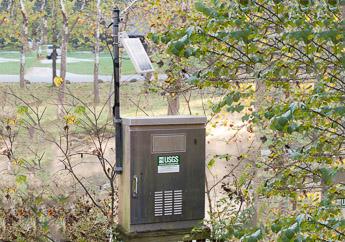
If you have ever crossed a highway bridge or hiked near a stream and noticed a metal structure with an antenna by the side of it, you have probably seen a streamgage. A streamgage contains instruments that measure and record a wide variety of parameters. Streamgages are commonly used to measure the stream stage (water level) and discharge. Stream stage is simply river depth set to a constant reference elevation, referred to as a datum. The river depth can be compared to other fixed elevations, such as flood stage, bridge height, road elevation, etc. Discharge is the amount of water moving down a stream or river per unit of time, commonly expressed in cubic feet per second (CFS) or gallons per day. Generally, these measurements occur automatically every 15 minutes or more frequently in times of flooding.
The U.S. Geological Survey (USGS) streamgage network is made up of thousands of streamgages across the United States. The department is a cooperator and supporter of the USGS streamgage network. To view the active streamgage in the nation, visit the USGS National Water Dashboard.
In Missouri, USGS maintains a network of 274 streamgages and 14 stations to monitor water level in Missouri lakes and reservoirs. Each streamgage is equipped with satellite telemetry to provide real-time information. USGS provides this information on the internet and works to assure data quality and corrects data if needed to assure a high degree of accuracy.
The streamgage network supports the following uses, among others:
- Real-time data to the public
- Planning, forecasting and warning about floods and droughts
- Project river stages to help protect life and property of Missouri citizens
- Water-resources planning and management purposes
- Engineering and design purposes
The department's Missouri Water Resources Center is working to build a network of streamgages across the state to measure water levels in stream channels. This network will complement the USGS Streamgage Network and provide additional valuable information to emergency personnel and the public.