Landslides and rockfalls are potential hazards in areas that have steep topography. Most Missouri bluffs are fairly stable, but some can pose problems. The most hazardous are bluffs that contain thick beds of sandstone or carbonate rock, underlain by shale. The shale will often preferentially weather to form a re-entrant beneath the harder rock, leaving large pieces of cantilevered rock. Rocks that fall from bluffs typically collect at their base. Geologists examine the bases of bluffs to estimate what size rockfalls they can produce.
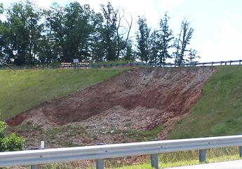
Steep slopes of loess, till, thick colluvium, alluvium and shale can be prone to landsliding. The problem is often exacerbated by seasonally high water tables. In general, the higher and steeper the slope, the further and faster the slide will move. Look for scallop-shaped scars along the slope and uneven or undulating ground at the base of slopes. Modifying slope toes can cause problems, even on slopes that appear stable. Care should be taken when modifying slopes and changing natural water courses in unconsolidated materials.
Geologic Mapping for Natural Disasters
The department partnered with the Missouri State Emergency Management Agency (SEMA) to create two series of maps to assist Missourians in their planning and response to a disaster. The Geologic Mapping for Natural Disasters website offers PDF maps for displaying, downloading and printing. This series of maps highlights the potential for geologic and natural hazards, while the Debris Management Map Series helps to provide guidance for the management of waste debris following a disaster. Mapping potential geologic hazards and determining preliminary site suitability for disposal of debris provide emergency planners and responders with vital information needed in the response of a disaster.