An important part to understanding groundwater is to study the geologic formations that make up the aquifers where groundwater exists or the confining units that hampers groundwater movement. Geologic formations are rock units that are unique enough in appearance that a geologists can tell it apart from surrounding rock layers. Geologists examine samples collect when drilling wells to determine the general physical characteristics of the rocks (lithology), mineralization, the rock arrangements (geologic structures) and aquifers the well passes through.
In the early 1900s, the Missouri Geological Survey (MGS) reached an informal agreement with the drilling industry. Drillers would collect samples of the rock cuttings from wells every five feet of drilling and send them to MGS. Geologists would examine the samples microscopically and create a well log.
Well Logs
Well logs are a detailed, graphic record that illustrates the geologic data collected from samples collect when drilling wells, along with location, production and well construction information. MGS maintains well log files, the most detailed source of Missouri subsurface geologic information. Today, logs exist for more than 28,000 wells. Not every well that has been drilled in Missouri has been logged, as there have been several hundred thousand wells drilled over the years. Approximately 3,000 new water wells are drilled every year.
- Well Drilling Logs Viewer – View and download well logs that contain well locations, construction details, water levels, geologic data and more using an ArcGIS mapper
- GeoSTRAT – Locate geologic, hydrologic and geotechnical data using an interactive ArcGIS map. Select “Well Logs” from the list of layers on the left side of the interface and zoom in until they are displayed, or search for an address.
- Geologic Well Log Symbol Key and Descriptions - PUB2932
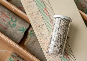
Rock Core and Cuttings
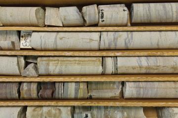
Core is a cylinder-shaped segment of subsurface rock obtained by using a hollow-stem drill and drill bit. This method of collection allows for continuous samples through the bedrock zones of interest. Core typically collected for research is 1.375 inches in diameter and stored in 2-foot segments. Cuttings are small pieces of rock that are pushed to the surface as a solid stem drill bit is advanced. Samples of cuttings are collected as they are flushed out of the borehole. The samples are then washed to remove and fine particles and placed into small vials for storage and later examination.
More than 1,300 handsamples and nearly 1,100 thin sections are stored at the department's McCracken Core Library and Research Center. Specimen locations and other information about each sample are included in the Excel file below. Locations, lithologies and stratigraphic units of outcrops from publications and field notebooks created by our geologists, as well as publications by authors across Missouri are included in the file.
Operation Basement: Missouri Precambrian Sample Database
In 1968, MGS established the Operation Basement program to obtain drill hole and underground mining data relative to the structure and composition of the buried Precambrian basement, expand mapping in the Precambrian outcrop area and conduct research related to Precambrian geology and mineral resources. This information was originally compiled in close cooperation with exploration and mining companies operating in Missouri, who provided drillhole data, core and rock samples to MGS. As of Sept. 13, 2017, the Operation Basement Microsoft® Access® database contains information from 915 drill holes that penetrated the Precambrian basement tabulated by county. When available, core logs and petrographic descriptions are included. This effort was supported through a cooperative agreement with the Mineral Resource Program of the U.S. Geological Survey.