For over a century, Missouri has been, and continues to be, one of the leading national producers in lead. Some of the largest lead deposits in the world are located in southeast Missouri, an area known as the Southeast Missouri Lead Mining District (SEMOLMD). The district covers multiple counties, from 40 to 90 miles southwest of St. Louis, and is located within seven watersheds including the Meramec River, Big River, Black River and St. Francis River.
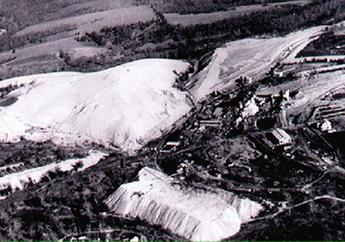
Lead has been mined in southeast Missouri since the early 1700s. The SEMOLMD includes the Old Lead Belt and the New Lead Belt, also referred to as the Viburnum Trend. With depleting ore reserves in the Old Lead Belt, early 1950s exploration for new lead and zinc deposits was implemented and the New Lead Belt was discovered. The Viburnum Trend sub-district is located south to southwest of the Old Lead Belt and east of the Tri-State Mining District. The Viburnum Trend continues active exploration and mining with several active lead mines.
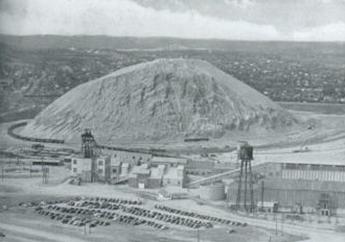
Two former lead smelters historically operated in or near the SEMOLMD. The Herculaneum smelter, located south of St. Louis just outside the SEMOLMD, began smelting operations in the late 1800s. Before it closed in 2013, the Herculaneum smelter was the largest active primary lead smelter in the United States. The Glover smelter, located in the Viburnum Trend near Ironton, Missouri, operated from 1968 until the early 2000s. From 1968 to 1987, the Buick Resource Recycling Facility operated as a primary lead smelter in the Viburnum Trend near Boss, Missouri. This facility now operates as an active secondary lead smelter and is the largest secondary lead smelter in the world. For more information about the history of lead mining in Missouri, visit Lead in Missouri.
Environmental Issues
Heavy-metal mining, smelting and transporting ore concentrate in southeast Missouri resulted in releases of hazardous substances and caused widespread injury to local natural resources and the services they provide. The Old Lead Belt contains several National Priorities List (NPL) Superfund Sites. The Big River Mine Tailings/ St. Joe Minerals Corp. site is located directly south of St. Louis, in St. Francois County. The Madison County Mines site spreads throughout Madison County. Additional sites have been added to the NPL as a result of ongoing releases of hazardous substances from the mining, beneficiation, smelting and transportation activities in the SEMOLMD. These NPL sites include: Annapolis Lead Mine, Southwest Jefferson County Mining and Washington County Lead District sites: Furnace Creek, Old Mines, Potosi and Richwoods. Currently no NPL designated sites fall within the Viburnum Trend.
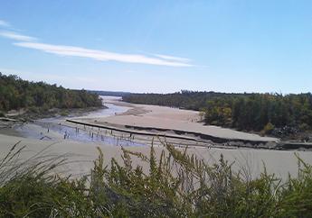
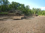
Restoration activities are part of the ongoing Natural Resource Damage Assessment and Restoration (NRDAR) process under the Comprehensive Environmental Response, Compensation and Liability Act (CERCLA), commonly known as Superfund. The legacy of heavy-metal mining caused large-scale ecological injury to thousands of acres of terrestrial habitat and dozens of miles of streams throughout this region. Natural Resource Damage Assessments have shown heavy metal contamination affecting terrestrial and aquatic life that depend on these impacted habitats. Natural resources injured by the releases of mining-related contaminants include surface water, stream sediments, fish, aquatic invertebrates, migratory birds and their supporting habitats, such as streams, riparian corridors, forests and savannas.
Trustees and Funding
Trustees
Under federal law, the State of Missouri acts on behalf of Missouri's citizens as a trustee for the state’s natural resources. The Governor of Missouri designated the Director of the Missouri Department of Natural Resources as the state natural resource trustee. The federal trustees for the SEMOLMD are the U.S. Department of Interior, represented by the U.S. Fish & Wildlife Service. The Mark Twain National Forest is public land found throughout the Viburnum Trend. Therefore, the U.S. Department of Agriculture, represented by the U.S. Forest Service, is also designated as a federal trustee for the Viburnum Trend sub-district.
Restoration Funding
Funding for selected projects comes from legal settlements with American Smelting and Refining Co. (ASARCO LLC), Magmont Joint Ventures and Freeport McMoRan for natural resources that were injured by releases of lead and zinc from mining and smelting at sites in the SEMOLMD. The Trustees compensates the public for the loss of natural resources as a result of lead and zinc contamination by using the settlement funds for ecological restoration. These projects include stream bank stabilization and terrestrial habitat improvement, along with securing and preserving high quality public lands.
Restoration Plan
The Trustees successfully recovered damages funds to use to restore impacted natural resources and their services throughout the SEMOLMD. According to CERCLA requirements, the SEMOLMD Trustees developed the Southeast Missouri Ozarks Regional Restoration Plan and Environmental Assessment in June 2014, as guidance for the restoration process in the SEMOLMD. The SEMORRP serves as an Environmental Assessment, as well as a Regional Restoration Plan. The Environmental Assessment is designed to consider alternatives that restore, replace, rehabilitate or acquire the equivalent to the natural resources and services injured by the release of hazardous substances in the SEMOLMD. The plan also serves to involve the public in the restoration plan, as well as comply with environmental requirements.
There is currently a public comment period open for the Big River Stream and Riparian Habitat Restoration in the Southeast Missouri Lead Mining District.
Projects
For information about any upcoming events, public notices and opportunities for public comment, visit What's New in NRDAR.
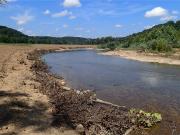
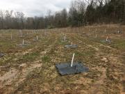
Big River and Meramec River Ecosystem Restoration
Floodplain and streambank restoration projects to address degraded ecosystems in the Big River due to lead mining.
Black River and Upper Big River Riparian Restoration
Riparian projects to restore or replace aquatic resources impacted from historic mining.
Little St. Francis River Pile Restoration
Restoration projects to restore former ASARCO chat pile and surrounding areas.
Contact Information
Natural Resource Damage Assessment and Restoration
Environmental Remediation Program
P.O. Box 176
Jefferson City, MO 65102-0176
United States