
Missouri is well-known for its karst geology, characterized by many sinkholes, caves and bedrock fractures. The Perryville Karst is one of several karst zoogeographic regions in Missouri and encompasses most of the eastern portion of Perry County, Missouri. Perry County leads the state in the number of known caves at more than 680. It also boasts some of the longest caves, such as Crevice Cave (45 km), Moore Cave System (29 km), Mystery Cave (25.5 km) and Rimstone River Cave (22.8 km). Perry County is a mixture of urban areas (3%), forests (46%), croplands (47%) and water and wetlands (3%). The urban areas are predominately residential with the exception of Perryville, which has three significant manufacturing facilities.
The Perry County Karst project area encompass approximately 145,893 acres. The project area was not determined by a specific watershed because groundwater flow paths do not fit with the surface topography. Caves, sinkholes, springs and losing streams are abundant – providing extensive connections between surface runoff, surface waters and shallow groundwater. Therefore, the project area was determined partially by the boundaries of the Perryville Karst Region and partially by the political boundaries of Perry County.
Water Quality Issues
Surface water resources within Perry County consist of private and public lakes, streams, and springs. There are 29 lakes and approximately 627 miles of streams in Perry County that are assigned designated uses in Missouri’s Water Quality Standards. These uses include aquatic life protection, recreation (e.g., swimming and boating), human health protection, irrigation, livestock and wildlife protection, and in some cases drinking water supply. Five streams in the project area are listed on the state’s 303(d) list as impaired, or not meeting water quality standards, due to E. coli, most listing nonpoint source pollution as the source of the impairment. These streams include Brazeau Creek, Cinque Hommes Creek, Dry Fork, McClanahan Creek and Omete Creek.
Sampling has also shown excessive sediment and nutrient loading to these streams, which has negative implications for aquatic communities. The federally endangered Grotto Sculpin, a troglomorphic fish, is common in five cave systems in the project area. Grotto Sculpin populations are highly susceptible to pollution through agricultural and urban runoff.
Watershed Management Plan
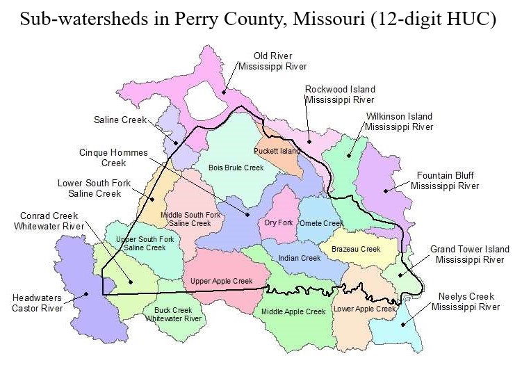
The Perry County Soil and Water Conservation District received a federal grant to fund the preparation of a watershed management plan for the Perry County portion of the Perryville Karst Region. The project area includes ten12-digit Hydrologic Unit Code (HUC12) subwatersheds: Bois Brule Creek (301), Dry Fork (302), Puckett Island (303), Omete Creek (304), Cinque Hommes Creek (305), Wilkinson Island-Mississippi River (307), Brazeau Creek (308), Indian Creek (402), Middle Apple Creek (403) and Lower Apple Creek (404). The plan is designed to focus the efforts of private, city, county, state and federal stakeholders on protecting surface water and groundwater health in the project area, as the county continues to urbanize and increase agricultural production. This project helps address watershed water quality concerns by implementing practices to address water quality impairments and concerns in the watershed as prescribed in the watershed based plan.
Project Goals
The following are the goals for addressing and reducing impairments within the Perry County Karst project area:
- Restore impaired surface waters impacted by nonpoint source pollution to state water quality standards, and protect Perry County Karst waters from future degradation
- Promote wise-watershed stewardship practices throughout the watershed planning area to reduce all sources of nonpoint source pollutants
- Protect unique karst habitats and the cave life they support including the federally endangered Grotto Sculpin
- Guide future implementation of voluntary conservation practices funded by Missouri’s nonpoint source pollution program
- Provide direction for multiple agencies and programs working to address water quality issues in the Perry County Karst watershed
The following are the objectives of the watershed management plan:
- Reduce E. coli pollution loading into waterbodies that are designated as impaired through either the state’s §303(d) list or through establishing total maximum daily loads
- Reduce nutrient, sediment and herbicide pollution loading into subsurface groundwater to protect karst habitat and the endangered Grotto Sculpin
- Restore and maintain designated uses for impaired waterbodies
Best Management Practices
Best management practices (BMPs) listed in the watershed based plan to be implemented near streams, sinkholes, springs and vertical drainpipes in the Perry County Karst project area to reduce erosion and transport of nutrients, sediment, herbicides and E. coli include, but are not limited to, the following:
- Livestock BMPs: Alternative (i.e. off stream) watering systems, livestock exclusion, managed grazing, pasture over seeding, structural waste systems, diversions, dead bird composting (poultry farms), animal confinement systems
- Cropland BMPs: Vegetative buffers, filter strips, native warm season grass buffers, no till, conservation tillage, cover crops, strip cropping, contour farming, terraces, ponds, water and sediment control basins, grade stabilization structures, grassed waterway
- Other BMPs: Stream bank stabilization, riparian corridor improvement, remove or repair malfunctioning vertical drainpipes, tree planting, timber stand improvement
- Urban BMPs: Infiltration systems, perimeter sand filters, infiltration trenches, baffle boxes, ordinances