Division of Environmental Quality Director: Art Goodin

The Little Sac River, which is a tributary to the Sac River, begins at the north edge of Springfield and Strafford, Missouri, forming Fellows Lake and McDaniel Lake, and stretches 41.5 miles north into Stockton Lake. Its major tributaries include Slagle Creek, North Dry Sac, South Dry Sac and Asher Creek. The 390-square mile watershed encompasses the towns of Willard, Walnut Grove and Morrisville. Upper Little Sac is comprised of seven 12-digit Hydrologic Unit Code (HUC12) subwatersheds: Headwaters Little Sac River, South Dry Sac River, Flint Hill Branch-Little Sac River, North Dry Sac River, Asher Creek-Little Sac River, Slagle Creek and Walnut Creek-Little Sac River.
The area is well-known for its karst geology, characterized by many sinkholes, caves and bedrock fractures connecting surface water and groundwater. There are two aquifers under the Little Sac River watershed: Springfield plateau aquifer (shallow) and Ozark aquifer (deep). The Springfield plateau aquifer provides agricultural and industrial water and Ozark aquifer provides municipal, agricultural and industrial water. The three lakes — Stockton, Fellows and McDaniel — are public drinking water sources for Springfield and Greene County residents.
This watershed has a diverse landscape that changes from very urbanized/ high-density population in the upper, southern part of the watershed, to rural agricultural land in the middle two-thirds and recreational areas surrounding Stockton Lake. The watershed consists mostly of grassland (67%) and forests (30%). The grassland designation includes hay, pasture and land enrolled in the Conservation Reserve Program (CRP). Hay and CRP land, which are sometimes considered cropland, behave more like grassland in this area. The watershed is part of the northeast and central farming forest region, with feed grains and hay as the main crops. Urban areas comprise 2.4% of the watershed.
Water Quality Issues
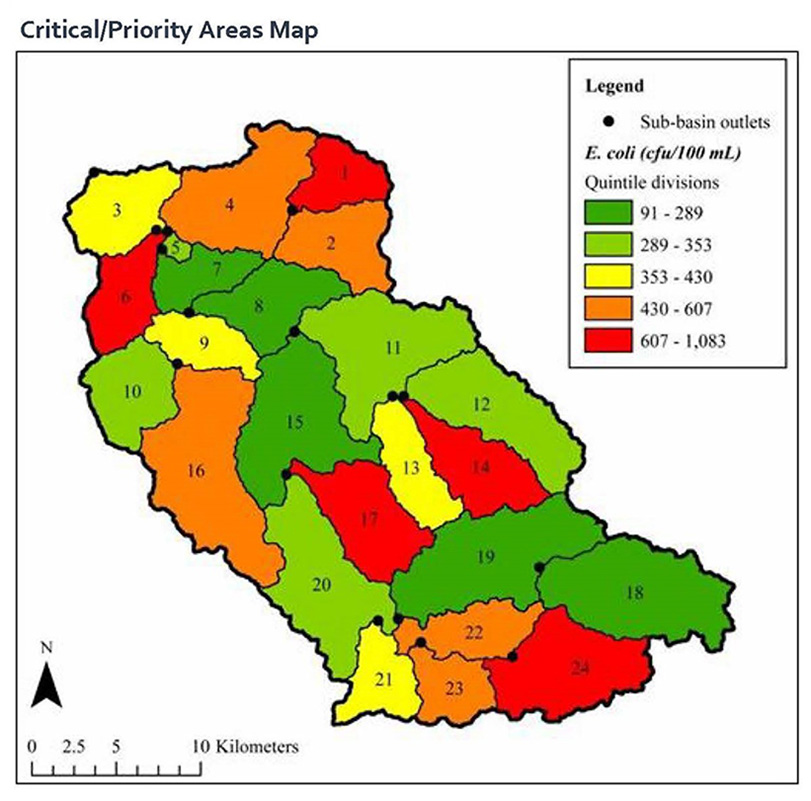
The Little Sac River had a 27-mile reach listed on the state’s 303(d) list as impaired, or not meeting water quality standards, due to E. coli in 1998 and 2002 (fecal coliform was the standard at that time). It has remained on the list due to E. coli concentrations that exceed the water quality standard for whole body contact. Asher Creek is also listed due to E. coli. Pea Ridge Creek is listed for Aquatic Macroinvertebrate Bioassessments (loss of biotic diversity). Fellows Lake is listed for atmospheric depositional mercury and McDaniel Lake is listed for Chlorophyll-a. Since this watershed is the main source of the public drinking water for Springfield, water quality is a priority.
The sources of the impairment are mainly nonpoint source pollution. The McDaniel Lake Total Maximum Daily Load was approved in 2004, to address nutrient impairments (algae) from agricultural and urban nonpoint source runoff. The Little Sac River Watershed Total Maximum Daily Load was approved in 2006, to address fecal coliform from point and nonpoint sources. The point source pollution was identified as the City of Springfield’s Northwest Water Treatment Plant. Since that time, the treatment plant has undergone major renovations and began disinfecting the effluent year-round using UV equipment. Now the main contribution of impairment is presumably from nonpoint sources in the watershed.
Watershed Management Plan
In October 2019, the Watershed Committee of the Ozarks updated the Upper Little Sac River Watershed Management Plan, originally written in 2009, to address issues related to the current Total Maximum Daily Load for the Little Sac River and the need to protect drinking water/ source water. This plan addresses the upper, or southern, portion of the Little Sac River Watershed (HUC #1029010604), which contains portions of Greene and Polk counties. In the future, the lower, or northern, portion of the watershed (HUC #1029010605) will be addressed. This watershed management plan will help protect and improve water quality in the rivers and streams, as well as in Fellows, McDaniel and Stockton lakes, by identifying pollutant sources, offering guidance for implementing best management practices (BMPs), setting reasonable goals, and developing a timeline for implementation. The updated plan also helps current and future monitoring evaluation programs to determine the success of implemented projects/ programs.
Project Goals
The goals of the Upper Little Sac watershed-based plan are to:
- Restore surface waters impaired by nonpoint source pollution as much as feasible
- Promote wise-watershed stewardship practices throughout the watershed to reduce all sources of nonpoint source pollutants
- Protect drinking source waters in the watershed
- Guide future implementation of voluntary conservation practices funded by Missouri’s nonpoint source pollution program (§319)
- Provide direction for multiple agencies and programs working to address water quality issues in the Upper Little Sac watershed
The objectives are to:
- Reduce E. coli pollution loading in waterbodies designated as impaired to achieve a long-term trend in water quality improvement
- Reduce the amount of nutrient and sediment pollution loading into watershed streams to protect drinking source waters
By implementing the BMPs as provided in the watershed plan, the expected 43% reduction in E. coli load exceeds the load reduction needed to achieve water quality standards – exceeding the plan’s goal of improving versus restoring impaired waters. Estimated load reductions were not provided for nutrients or sediment, but are expected as a result of BMP implementation for E. coli load reduction.
Best Management Practices
In keeping with the Little Sac River Watershed Total Maximum Daily Load, many of the BMPs in the watershed plan are focused on reducing E. coli present in the river. The BMPs also address other water quality issues such as education, stormwater runoff, nutrients and sediment. Below is a summary of BMPs listed in the watershed-based plan:
- Reduce Bacteria Pollution: Stream corridor improvement and protection, soil health and restoration, riparian habitat improvement, nutrient management, remediate and improve failing onsite wastewater management systems (septic systems), water protection for wells, sinkholes, caves and springs
- Reduce Sediment Erosion: Rotational grazing management and solar watering, sheet/ rill erosion prevention, forage management
- Reduce Stormwater Runoff: Tree planting, rainwater collection, lakeshore stabilization, detention basin retrofits, waterfowl deterrent
- Increase Watershed Education and Awareness
Nothing in this document may be used to implement any enforcement action or levy any penalty unless promulgated by rule under chapter 536 or authorized by statute.
For more information
Section 319 Nonpoint Source Unit
Water Protection Program
Water Pollution Control Branch
P.O. Box 176
Jefferson City, MO 65102-0176
United States