Missouri Geological Survey Director: Carey Bridges, RG
Rhyolite is an igneous, volcanic rock composed chiefly of quartz and feldspar. Rhyolite formed when lava and volcanic ash erupted from ancient volcanoes and cooled very rapidly. It makes up most of the steep, high knobs that form the St. Francois Mountains in southeast Missouri.
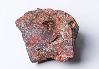
Rhyolite exposed in Missouri is extremely dense and fine-grained. Resistant to weathering, it is a compact, hard, brittle rock. Referred to by stone producers as a “traprock,” Missouri rhyolite varies in color from light gray through pink and red to dark purplish-red. Sometimes it has a distinct banded pattern.
The stone is known for its natural beauty, durability and utility. Rhyolite quarried in Missouri was historically used in the manufacture of paving blocks and roofing shingles, for high-quality construction aggregate, as road metal (crushed rock used to construct a road) and for other purposes.
Today, rhyolite continues to be a very important resource for the state’s transportation infrastructure and construction industries as it is used as a road metal, a high-quality construction aggregate and for making granules for roofing shingles.
Rhyolite is a core feature in some of Missouri’s most spectacular scenery and popular state parks, including Johnson’s Shut-Ins State Park and Taum Sauk Mountain State Park. Each of these parks owes its unique character to the igneous rocks and to the geologic processes that have formed and shaped them.
The St. Francois Mountains provide a rare glimpse into rocks formed by the most violent type of volcanic eruptions known on the earth. Consequently, geologists come from around the world to study them, and visitors take in all the area has to offer, including climbing to the top of Taum Sauk Mountain to be on top of Missouri – literally. Taum Sauk Mountain, in Taum Sauk Mountain State Park, rises to 1,772 feet above sea level – the highest point in the state. The park’s 7,500 acres also includes Mina Sauk Falls, the state’s tallest waterfall. The moderately rugged Mina Sauk Falls loop trail takes visitors to Mina Sauk Falls, which drops 132 feet down a series of rocky rhyolite ledges into a clear, rock-bottom pool that sits at the base.
Devil’s Tollgate lies one mile below the falls along the Taum Sauk Section of the Ozark Trail. This 8-foot-wide passage takes visitors through 50 feet of rhyolite standing 30 feet high.
The Ozark Trail continues on to nearby Johnson’s Shut-Ins State Park, in Reynolds County where the East Fork of the Black River winds its way through rhyolite bedrock. The Black River eroded a channel down to the purplish volcanic rhyolite, creating a series of rock shoots and channels – called a shut-in – making it a dramatically beautiful, natural place to enjoy the water.
Visit the department’s Ed Clark Museum of Missouri Geology, where you will find rhyolite on display.
Nothing in this document may be used to implement any enforcement action or levy any penalty unless promulgated by rule under chapter 536 or authorized by statute.
For more information
Geological Survey Program
Missouri Geological Survey
P.O. Box 250
Rolla, MO 65402-0250
United States