
Division of Environmental Quality Director: Art Goodin
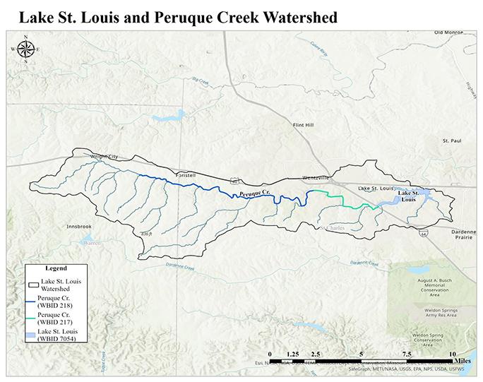
In July 2026, the Missouri Department of Natural Resources, in cooperation with the Peruque Creek Watershed Alliance, developed a watershed-based plan in conjunction with developing a Lake St. Louis Total Maximum Daily Load (TMDL) report to address the chlorophyll-a impairment. The Peruque Creek Watershed Alliance is a local watershed group made up of local municipal partners, private businesses, local stream team volunteers, homeowner associations, citizens living in the watershed and others.
The watershed management plan is intended to provide a continuing framework for the department and the alliance to work with landowners, communities and organizations in the watershed to voluntarily implement best management practices (BMPs) to meet and protect water quality standards. It also provides opportunities for eligible entities to apply for Clean Water Act Section 319 funding to support such implementation.
This plan specifically targets restoration and load reductions to address the Lake St. Louis chlorophyll-a impairment, however it is expected to also improve and potentially restore water quality in Peruque Creek.
Watershed Description
Lake St. Louis, water body ID (WBID) 7054, is a 444-acre lake located in eastern central Missouri, between Wentzville and O'Fallon, in St. Charles County. It was created by impounding Peruque Creek, WBIDs 217 and 218. Peruque Creek is the main tributary to Lake St. Louis, originating in Warren County and running 56 miles east into Lake St. Louis. The stream flows parallel to Interstate 70, through the municipalities of Foristell, Wentzville, Lake St. Louis and O’Fallon, Missouri. The lake and stream are located in the Headwaters Peruque Creek 12-digit Hydrologic Unit Code (HUC12) subwatershed (HUC #071100090101), which is part of the the Peruque-Piasa HUC8 subbasin (HUC #07110009).
The Lake St. Louis watershed is a mix of agricultural (37.7%), developed land (30.8%) and forested areas (29.2%). Rapid urbanization is occurring within the watershed. The lake itself is located within the boundaries of the Lake Saint Louis municipality and is managed by a private homeowner’s lake association.
Water Quality Issues
Both Peruque Creek and Lake St. Louis are listed on the state’s 303(d) list as impaired. Low dissolved oxygen conditions and low aquatic macroinvertebrate diversity have been documented on a 10.9 mile segment of Peruque Creek. All classified waters of the state must provide suitable conditions for aquatic life, including both the physical habitat and the quality of the water. If concentrations of dissolved oxygen drop too low, fish and other organisms begin to suffer and die. The impaired segment of Peruque Creek runs eastward from just south of Archer Road to just east of Highway Z, with the drainage area for the impaired segment being approximately 38 square miles.
Lake St. Louis is impaired for exceeding Missouri’s lake numeric nutrient criteria. These impairments are the result of excessive sediment and nutrients entering the lake from the surrounding landscape and from Peruque Creek, which is the primary source of flow to the lake. Pollutant loading to Lake St. Louis comes from a combination of point and nonpoint source pollution; including wastewater treatment facilities, agricultural runoff, urban development, leaky septic systems, atmospheric deposition and natural background conditions.
Major sources of nonpoint source pollution in the Lake St. Louis watershed are runoff from areas with agricultural land uses as well as from expanding development and rapid urbanization occurring in the watershed. In some of these areas, those major sources also contribute to or exasperate streambank erosion that may also contribute excess sediment or phosphorus.
| Waterbody Name and ID | Size | Impairment(s) | Impairment Source(s) | Impaired Use |
|---|---|---|---|---|
| Peruque Creek (217) | 4 miles |
|
| None |
| Peruque Creek (218) | 10.9 miles |
|
| Aquatic Life-Warm Water Habitat |
| Lake St. Louis (7054) | 444 acres |
|
| Aquatic Life-Warm Water Habitat |
Project Goals
The goals of this watershed management plan are to restore the aquatic life designated use assigned to Lake St. Louis, and to ensure continued protection of the use once water quality criteria are met. Specific objectives include the following:
- Achieve necessary nonpoint source phosphorus, nitrogen and sediment load reductions to meet the applicable chlorophyll-a criteria in Lake St. Louis through implementing BMPs.
- Reduce excess sedimentation and the potential for harmful algal blooms in Lake St. Louis.
- Protect aquatic life designated uses in the Lake St. Louis watershed.
- Reduce excess sedimentation, which contributes to nutrient, biological and low dissolved oxygen impairments in the Lake St. Louis watershed.
Best Management Practices
Implementing BMPs to achieve the stated load reductions for Lake St. Louis will address the impairment and attain water quality standards. Below are the load reductions needed to meet water quality standards:
- Total nitrogen (TN) - 6,657 tons per year.
- Total phosphorus (TP) - 135,335 pounds per year.
- Total suspended solids (TSS) - 35,677 pounds per year.
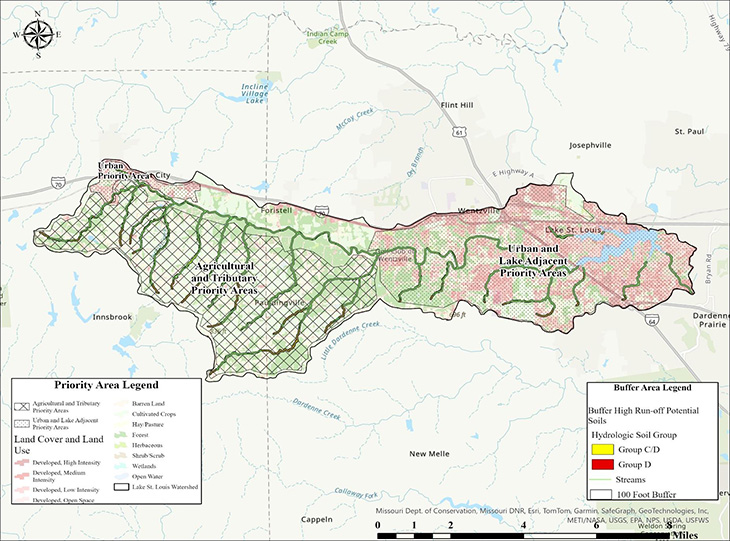
In order to determine critical areas and prioritize BMP implementation, a four-tier approach is being applied based on contributing land use types and factors influencing pollutant loading from sources in the watershed. These tiers identify critical to more general areas for BMP implementation.
- Tier 1 (highest) - 100-foot stream buffer areas classified as urban, row crop, pastureland or barren lands uses and have high run-off potential soils (e.g., Group D and C/D), targeting active land use development.
- Tier 2 - 100-foot stream buffer areas which are classified as urban, row crop, pastureland or barren lands uses, targeting active land use development.
- Tier 3 - Target specific watershed land use activities - active row crop and pastureland areas, areas of increasing urban development. Areas of active land disturbance and locations which optimize watershed stormwater controls should be prioritized.
- Tier 4 (lowest) - Targeted watershed land use types for load reductions: Row crop, pasturelands, and urban development.
The plan describes several types of BMPs to implement in the watershed over a 35-year period. Types of BMPs, as well as the amount of area needing to be treated by those BMPs, to achieve the targeted load reductions were modeled using the U.S. Environmental Protection Agency’s (EPA) Pollutant Load Estimate Tool (PLET). There are a variety of BMPs which can be implemented in agricultural, urban and stream channel settings to address excessive sediment loss and control nutrient loading within a watershed.
Pastureland BMPs
- Grass Buffer
- Forest Buffer
- Critical Area Planting
- Heavy Use Protection
- Stream Bank Stabilization
- Prescribed Grazing
- Exclusion Fencing
Cropland BMPs
- Cover Crops
- Conservation Tillage
- Grass Buffer
- Forest Buffer
- Land Retirement
- Contour Farming
Urban BMPs
- Designed Wetland and restoration
- Extended Stormwater Retention
Information and Education
The Peruque Creek Watershed Alliance has and will continue to initiate and provide support for this watershed management plan. Examples of outreach and educational activities include:
- Watershed and lake tours
- Volunteer water quality sampling
- Water quality education events
- Installing educational signage
- Publishing newsletter articles
- Public meetings
Future events will be scheduled throughout the implementation schedule and integrated into future watershed implementation activities. Specific education and outreach efforts anticipated to be implemented during the period of this plan are outlined in Section 10 of the watershed management plan.
Nothing in this document may be used to implement any enforcement action or levy any penalty unless promulgated by rule under chapter 536 or authorized by statute.
For more information
Section 319 Nonpoint Source Unit
Water Protection Program
Water Pollution Control Branch
P.O. Box 176
Jefferson City, MO 65102-0176
United States