
The land area between Columbia and Ashland, Missouri, stretching west to the Missouri River, is home to many notable features, including Rock Bridge Memorial State Park, Three Creeks Conservation Area, multiple caves and streams. This approximately 92.4 square mile area encompasses the Greater Bonne Femme watershed and includes both the Bonne Femme and Little Bonne Femme creeks, which flow directly into the Missouri River near Easley, Missouri. The Greater Bonne Femme watershed includes two of the five subwatersheds that make up the Splice Creek-Missouri River 10-digit Hydrologic Unit Code (HUC10) watershed (HUC #1030010209). The Little Bonne Femme Creek-Missouri River subwatershed (HUC #103001020903) is located just south of Columbia and the Bonne Femme Creek subwatershed (HUC #103001020902) is located just north of Ashland. Tributaries within the watershed include Bass Creek, Turkey Creek, Fox Hollow Branch, Smith Branch, Devil's Icebox Branch, Gans Creek, Clear Creek and Mayhan Creek.
Land use in the watershed is mixed and includes cultivated crops (13%), livestock pasture/ hay (33%), urban (9%), forest (43%) and other (2%). Row cropping and pasturing of livestock occurs mainly on the east side of Highway 63. The west side of Highway 63 is largely forested and is well-known for its karst geology, characterized by many losing streams, sinkholes, caves and bedrock fractures connecting surface water and groundwater. Rock Bridge Memorial State Park lies in the Little Bonne Femme subwatershed, with a long reach of Little Bonne Femme Creek running through the park as it makes its way to the Missouri River. Park visitors can also see the Devil’s Icebox Cave System with its rock bridge, sinkholes, a spring and underground stream. Three Creeks Conservation Area lies in the Bonne Femme Creek subwatershed and takes its name from the three creeks that run through the area: Turkey Creek, Bass Creek and Bonne Femme Creek. Three Creeks has spectacular karst features of its own including karst windows and Hunter’s Cave.
Water Quality Issues
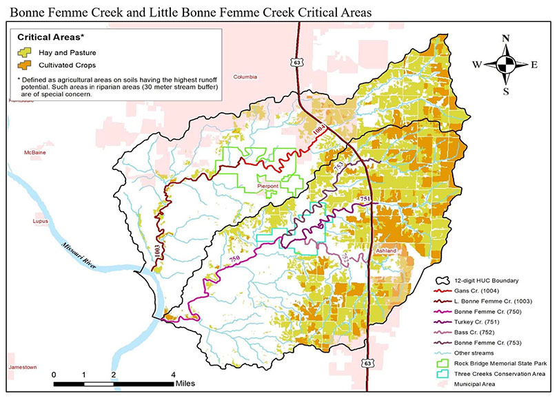
Currently, five streams within the Greater Bonne Femme Watershed are listed on the state’s 303(d) list as impaired, due to E. coli concentrations that exceed the water quality standard for whole body contact: Bass Creek, Bonne Femme Creek (upper and lower), Gans Creek, Little Bonne Femme Creek and Turkey Creek. The source of the impairment listed for Bass, Bonne Femme and Gans creeks is rural nonpoint source pollution. The source of the impairment listed for Little Bonne Femme and Turkey creeks is shown as source unknown. Threats to stream and water quality include the following:
- Collapse of stream banks, deforestation of riparian areas, microbial contamination from on-site sewage systems sediments, nutrients and pesticides in stormwater runoff from residential, commercial and industrial sites
- Animal wastes in stormwater runoff from pastures
- Sediments, nutrients and pesticides in stormwater runoff from row crops
Recent trends show rapid development in Ashland and Columbia, where population growth has increased by 40% over the last 10 years. Building density and overall impervious surface area has increased in the watershed. Recently, several large tracts of land that were formerly in agricultural production have been converted to planned residential developments or single-family dwellings on 2.5- to 10-acre lots.
Watershed Management Plan
In 2023, Boone County and project partners, including local government, state and federal agency, nongovernmental organization, and local landowner partners, initiated the Greater Bonne Femme Watershed Project to develop a watershed-based plan for Bonne Femme and Little Bonne Femme subwatersheds. Originally developed in 2007, the updated the Greater Bonne Femme Watershed Management Plan was created to help improve and protect water quality in the watershed by identifying pollutant sources, identifying better management practices to be implemented, setting reachable goals and a timeline for implementation projects, and establishing an evaluation and monitoring program. The project also implemented a best management practice (BMP) demonstration project to inform the public about practices that can be installed to address the streams’ bacteria impairment.
The water quality concerns and threats addressed in the watershed plan include bacteria (E.coli), excessive nutrients and sediment. Sedimentation in the Devil’s Icebox Cave system was previously correlated to a decreased abundance of endemic pink planarians in the cave. Fate and transport of sediment is therefore of particular concern in the Devil’s Icebox recharge area.
Project Goals
Boone County and project partners wanted to consider the potential impact of new and future developments on natural communities and ecosystems in the Greater Bonne Femme watershed. The committee strives to foster watershed management that invests in the environment, which will allow communities and their economies to grow and thrive. Boone County and project partners worked to develop the watershed-based plan with the following goals:
- Restoration, Protection and Adaptive Management - Restoration and protection will be achieved using adaptive management methods. Interdisciplinary approaches incorporating science (physical, biological, chemical, economic and social) and policy will be used in an adaptive manner to address the unique challenges and opportunities presented by restoration and protection strategies and changing conditions over time.
- Integrating the watershed plan implementation with the Municipal Separate Storm Sewer System (MS4) permit held jointly by Boone County, the City of Columbia and the University of Missouri. Any future Section 319 grant funded projects will be above and beyond all MS4 permit requirements.
- Ratification of the watershed plan by the City of Columbia, City of Ashland and University of Missouri, with a dual objective of promoting increased uniformity of stormwater and building regulations and improving coordination with state and federal agencies to restore and protect water quality throughout incorporated and unincorporated areas of Boone County.
- Identification and engagement of stakeholders in future conversations about the GBFW and land management impacts at multiple geographic scales through the information and outreach approaches discussed in the watershed plan and land management impacts at multiple geographic scales through the information and outreach approach.
Best Management Practices
Boone County and project partners will work to engage landowners and other stakeholders to encourage voluntary implementation of the recommended BMPs on privately owned land. Funding to help producers and other stakeholders implement these practices is available through state and federal cost-share programs and grant funding. Below is a summary of the recommended watershed-wide BMPs for the Greater Bonne Femme Watershed.
- Livestock exclusion
- Grazing management
- Fencing
- Alternative watering source
- Vegetated buffers with and without trees
- Streambank buffer
- Bioretention basin
- Detention pond
- On-site septic pumpouts