Are you prepared for when the Meramec floods?
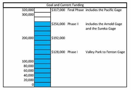
Phase Map of the Meramec Flooding Proposal
Problem:
The Meramec River is the longest free-flowing river through east-central Missouri and has been a source of flood damage for many years. Despite the known hazards of flooding, emergency management teams suffer from a lack of information both during and after floods. Municipalities, industries and residents have to make quick and expensive decisions regarding evacuation and removal of equipment and property.
Proposal:
The United States Geological Survey (USGS) Missouri Water Science Center (MOWSC) proposes to develop online flood inundation mapping tools (FIMS) for a selected reach of the lower Meramec River. (Check out a similar project in Kansas City, Mo). The Meramec River floodplain is well suited for estimated flood inundation mapping because of the availability of stage and discharge data at both of these streamflow gages. For more information on this available data, please check out the National Weather Service website.
Costs:
The total estimated cost to develop and publish USGS FIMs for the Lower Meramec River from the Pacific Gage to the Arnold Gage would be $317,000 (see map). The funding for the first two phases, $256,000, has been secured and mapping has begun for the first phase from the Valley Park Gage to the Fenton Gage. Flood Inundation Maps could also be developed along the Meramec for the reach at the Pacific Gage for an additional cost of $64,000. There have been discussions around developing maps along the Bourbeuse River as well. More information on the details of the map development is available on the USGS website.
Sneak Preview:
A flood inundation map library is the full set of maps showing flood inundation from near bankfull river levels to record flooding levels, as this picture shows:
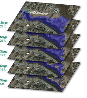
Here are two layers of maps that the USGS has created for phase I of the Lower Meramec River project:

Public costs of flooding in Missouri are high. St. Louis area floods facts from USA Today online Jan. 8, 2016:
- Around 7,100 structures have been damaged or destroyed.
- Over $200 million of road repairs in St. Louis County.
- Debris needed to be removed totaled over a half million tons.
Having an evacuation plan in place before a flood occurs can help avoid confusion and prevent injuries and property damage. A thorough evacuation plan should include:
- Knowing when to evacuate.
- Planning what to do and how to do it.
- Knowing where to go.
Additional information regarding flood preparedness information from Missouri Department of Public Safety and Missouri Department of Health and Senior Services.
Flooding is a national problem...but part of the solution is local
If you think this tool would have value to your agency or community, we encourage you to sponsor the USGS Flood Inundation Mapping project to ensure all phases of the project can be completed.
How this tool can help:
- Incorporate information from:
- The National Weather Service.
- HAZUS (a loss and risk assessment software package developed by the Federal Emergency Management Agency (FEMA).
- Includes information like vehicle loss, building loss and shelter requirements for displaced populations.
- Allow municipalities and utility services to get their resources aligned sooner.
- Once developed, it would be free for citizens to use.
- Communicates risk and consequences that can be used as a tool for flood preparedness, response (tied to gage and forecast data), recovery and mitigation, and planning.
What this tool does not do:
- Eliminate flooding.
- Replace FEMA flood plain maps regarding flood plain regulations or insurance determinations.
More information on the details of the map development is available on the USGS website.
What you can do:
- Do not wait until the National Weather Service issues a formal "Flood Warning" to start getting prepared,
- Plan in advace to afford extra critical time when a flood is coming, and this will help increase the odds of protecting valuable documents, real estate and personal property--including cherished belongings
Is flooding the Meramec River's "New Normal?"
The National Weather Service provides historical data at the five gages along the Lower Meramec. The USGS FIM Program helps communities protect lives and property by providing tools and information to help them understand local flood risks and make cost-effective mitigation decisions.
Funding for this project, and others like it, is provided through sponsorships or cooperative agreements from federal, state and local stakeholders who would directly benefit from the project. The first phase of this project (from Valley Park to Fenton) is being funded by USGS, United States Army Corps of Engineers (USACE), the Metropolitan St. Louis Sewer District (MSD), the Missouri Department of Transportation (MoDOT), Missouri American Water, the Federal Emergency Management Agency (FEMA) and the Missouri Department of Natural Resources. Mapping for phase I has begun. Potentially the Phase I project will be completed by December of 2017.
The second phase of this project (from Eureka to Valley Park and from Fenton to Arnold) is being funded by the department, MSD, USGS and the communities of Arnold, Eureka, Fenton and Wildwood. Mapping is projected to begin in the near future. Phase II has a projected timeline of 18 months.
The timing of future phasing is dependent on funding. Please discuss this project and the need for the development of this tool with leaders in the affected communities. To begin the sponsorship process or for more information, please contact Amy Beussink, Director of USGS Missouri Water Science Center at 573-308-3665.
Do not wait until the National Weather Service issues a formal "Flood Warning" to start getting prepared
Planning in advance can afford extra critical time when a flood is coming, and can help increase the odds of protecting valuable documents, real estate and personal property--including cherished belongings.
Partners