Missouri Geological Survey Director: Carey Bridges, RG
The Indian Creek streamgage near Lanagan is owned by the U.S. Geological Survey (USGS) and funded in cooperation with the Missouri Department of Natural Resources. Stage (water-surface elevation) measurements are made and recorded at 15-minute intervals and transmitted to the USGS office every hour. Stage and streamflow values are displayed in near real-time.
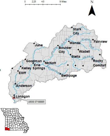
Indian Creek is a stream in McDonald County originating in the Ozark Highlands near Boulder City, MO. It flows into the Elk River near Lanagan. It was named for its history as a Native American rendezvous point during the county’s early history (Bell).
The streamgage is at the State Route EE bridge over Indian Creek near Lanagan in McDonald County and consists of a shelter, a data collection platform, a rain gage, an electronic pressure transducer to measure stage, a crest stage gage to automatically record crest height during high water events and a wire weight gage (Figure 3) used to manually verify electronic measurements. Learn how a USGS streamgage works.
Streamgage Information
- Streamgage Drainage Area: 239 square miles
- 10-Digit Hydrologic Unit Code: 1107020803
- Area of HUC10 Basin: 242 square miles
- Gage Location: 36°35'57.4", -94°26'58.7" (McDonald County)
- Gage Datum: 830 feet above NAVD88
USGS Tools
- Maximum, Minimum, Average Water Temperature: Nov. 1, 2004 to July 2010
- Precipitation (inches): April 8, 2019 to present
- Average Discharge (cubic feet per second): May 24, 2000 to present
- Observation Gage Height (feet): Nov. 6, 2000 to present
- Peak: Gage Height, Discharge (feet, cubic feet per second) 16.6, 33,600 (April 29, 2017)
The Indian Creek near Lanagan streamgage webpage is maintained by USGS. Users are able to create graphs and tables utilizing the recorded parameters, which can be customized to show current and historical observations, daily data, daily statistics, monthly statistics, annual statistics, peak streamflow and field measurements for any time frame within the period of record. A location map and Water-Year Summary also are available. Customize your own data output online.
Why is the Indian Creek Streamgage near Lanagan Important?
The streamgage provides recreational users in the area, surrounding landowners and the public with accurate stream height data. The Water Resources Center uses discharge data from this streamgage for flood, drought and water supply studies.
In the area, people can enjoy:
- Bird-watching
- Canoeing and Kayaking
- Camping
- Hiking
- Fishing
For more information about recreation activities located within the basin, contact the Missouri Department of Conservation.
P1010558.jpg
Figure 3. Wire weight gage.
P1010560.jpg
Figure 4. Area profile. Photo taken following flood.
1 References Cited
Bell, Margaret E. "Place Names In The Southwest Border Counties Of Missouri." M.A. thesis., University of Missouri-Columbia, 1933.
Nothing in this document may be used to implement any enforcement action or levy any penalty unless promulgated by rule under chapter 536 or authorized by statute.
For more information
Water Resources Center
Missouri Geological Survey
P.O. Box 176
Jefferson City, MO 65102-0176
United States