Missouri Geological Survey Director: Carey Bridges, RG
The Big Sugar Creek streamgage near Powell, MO, is owned by the U.S. Geological Survey (USGS) and funded in cooperation with the Missouri Department of Natural Resources. Stage (water-surface elevation) measurements are made and recorded at 15-minute intervals and transmitted to the USGS office every hour. Stage and streamflow values are displayed in near real-time.
Big Sugar Creek is a stream in southwest Missouri with headwaters in Barry County in Missouri and northwestern Arkansas. The stream is considered a Class II rapid and is used for paddling (Canoe). Big Sugar Creek State Park is named after the river and has rare vegetation not found in the rest of the state, such as the Ozark Chinquapin tree, Ozark corn salad wildflower, mock orange and low prickly pear cactus (Parks). Big Sugar Creek was named by settlers for the large groves of sugar maple trees surrounding it (Bell).
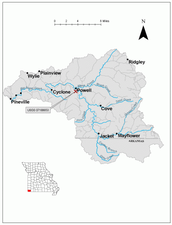
The streamgage is located on Big Sugar Creek off Cowan Bridge Road close to the historic Powell Bridge near Powell in McDonald County and consists of a shelter, a data collection platform, a rain gage, an electronic pressure transducer to measure stage, a crest stage gage to automatically record crest height during high water events and a wire weight gage used to manually verify electronic measurements. Learn how a USGS streamgage works.
Streamgage Information
- Streamgage Drainage Area: 141 square miles
- 10-Digit Hydrologic Unit Code: 1107020801
- Area of HUC10 Basin: 278 square miles
- Gage Location: 36°36'57", -94°10'56" (McDonald County)
- Gage Datum: 971 feet above NAVD88
USGS Tools
- Precipitation (inches): April 3, 2019
- Average Discharge (cubic feet per second): May 25, 20000 to present
- Observed Gage Height (feet): Sept. 30, 2022 to present
- Peak: Gage Height, Discharge (feet, cubic feet per second): Aug. 8, 2013
The Big Sugar Creek near Powell streamgage webpage is maintained by USGS. Users are able to create graphs and tables utilizing the recorded parameters, which can be customized to show current and historical observations, daily data, daily statistics, monthly statistics, annual statistics, peak streamflow and field measurements for any time frame within the period of record. A location map and Water-Year Summary also are available. Customize your own data output online.
Why is the Big Sugar Creek Streamgage near Powell Important?
The streamgage provides recreational users in the area, surrounding landowners and the public with accurate stream height data. Floaters can use the observed stream height to determine if there is adequate flow. The Water Resources Center uses discharge data from this streamgage for flood, drought and water supply studies.
In the area, people can enjoy:
- Bird-watching
- Nature photography
- Camping
- Hiking
- Backpacking
- Horseback riding
- Canoeing and Floating
For more information about recreation activities located within the basin, contact the Missouri Department of Conservation.
P1010575.jpg
Figure 3. Bridge profile.
P1010573.jpg
Figure 4. Old and New Powell bridges.
1 References Cited
Bell, Margaret E. "Place Names In The Southwest Border Counties Of Missouri." M.A. thesis., University of Missouri-Columbia, 1933.
Missouri Canoe & Floaters Association
New Powell Bridge to open today
Nothing in this document may be used to implement any enforcement action or levy any penalty unless promulgated by rule under chapter 536 or authorized by statute.
For more information
Water Resources Center
Missouri Geological Survey
P.O. Box 176
Jefferson City, MO 65102-0176
United States