Division of Environmental Quality Director: Art Goodin

The North Fabius River originates in southern Iowa and extends roughly 83 miles southeastward through several Missouri counties, where it joins the 75.7 mile long Middle Fabius River in southeastern Lewis County, Missouri. The North Fabius flows another 8.9 miles before merging with the South Fabius River in northeastern Marion County to form the Fabius River. The Fabius River then flows only 3.5 miles before reaching its confluence with the Mississippi River in the Fabius Chute near River Mile 323. For our purposes here, we will only be discussing the North and MIddle Fabius rivers.
Encompassing the North Fabius River and Middle Fabius River watersheds, the North Fabius 8-digit Hydrologic Unit Code (HUC8) subbasin (HUC #07110002) is a long, narrow drainage areas, extending across Schuyler, Scotland, Adair, Clark, Knox, Lewis, and Marion counties. The North Fabius subbasin encompasses about 585,736 acres, with the North Fabius River watershed draining 315,512 acres (493 sq. miles) and the Middle Fabius River watershed draining 270,223 acres (422 sq. miles). The land uses and covers throughout the subbasin are mostly rural and agricultural. Land use breaks down as follows: hay/pasture (35%), cropland (22%), urban (21%), forest/ herbaceous (18%) and water and wetland (3%).
Water Quality Issues
In 1998 and 2002, the North Fabius River was included on the state's 303(d) list as impaired, or not meeting water quality standards, due to sediment pollution from agricultural nonpoint sources. In addition the sediment impairment, water quality concerns in the North Fabius planning area also include high concentrations of pollutant loading, such as nutrients (nitrogen, phosphorus), bacteria (E.coli) and chemicals. Stream channelization, bank clearing and channel widening have resulted in loss of total stream area and usable habitat and increased streambank and streambed erosion. The increase in land conversion to row crop agriculture has resulted in sheet and rill erosion, gully erosion and nutrient runoff. The increase in land conversion from pasture and hay land to row crops has also resulted in increased use of herbicides and pesticides. Improper application of animal nutrients to crop and pastureland may also contribute to nutrient loading in waterbodies. Livestock that have direct access to streams also contribute to water quality issues by trampling riparian corridors, degrading streambanks and depositing waste directly in the waterbody.
According to Missouri’s Water Quality Standards, all waters of the state must provide suitable physical habitat and water quality for aquatic life. The North Fabius River Total Maximum Daily Load (TMDL) was approved by the U.S. Environmental Protection Agency in November 2006, to address the sediment impairment.
Watershed Management Plan
In 2010, Schuyler County Soil and Water Conservation District developed a watershed based plan for the North and Middle Fabius River watersheds in response to the North Fabius River being listed as impaired. The plan was updated in 2020 and addresses nonpoint source pollutants of concern that were identified by local stakeholders. The intent was to fully analyze the watersheds, make recommendations toward improving water quality, and provide watershed-level recommendations for surface water management.
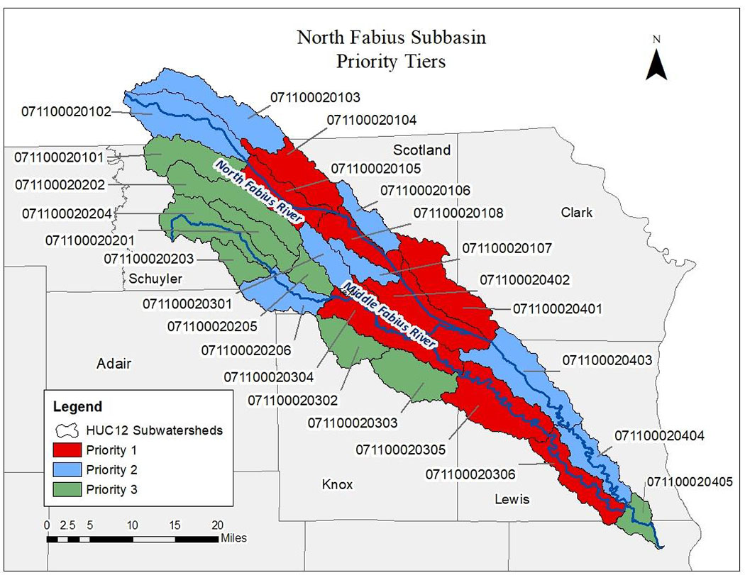
The North and Middle Fabius project area contains 25 HUC12 subwatersheds. Many of the issues identified in the watershed are assessed at these subwatershed levels. In order to effectively target implementation efforts, the subwatersheds were prioritized into three priority tiers according to average annual sediment loading. The eight subwatersheds with the greatest estimated sediment loading were set as Priority 1 Areas and will be targeted for implementation within the first 5 years of the 2020 watershed based plan.
Project Goals
The overall goal of the North and Middle Fabius watershed based plan is to implement the North Fabius River TMDL, restore aquatic habitats and bring the North Fabius River to the state’s water quality standards. The plan promotes a functioning, healthy watershed and guides the development, enhancement and implementation of actions to achieve these goals:
- Goal 1: Implement an Information/Education and Outreach Program targeting North Fabius watershed stakeholders to inform and educate conservation measures to improve water quality
- Goal 2: Implement best management practices (BMPs) to address the stream impairments and improve water quality to TMDL or water quality standards limits
- Goal 3: Conduct yearly monitoring and modeling in the North Fabius watershed to track water quality improvement over time
These objectives will be implemented to meet the goals:
- Create public awareness and involvement in water quality issues
- Provide information about water quality issues and how all community sectors, partners and stakeholders affect water quality within the watershed
- Promote relationships and networks among local leaders, agricultural producers, landowners and residents to promote watershed management programs targeting erosion and sedimentation, nutrient and chemical runoff, loss of fish and wildlife resources, and maintenance of water quality for recreational use
- Target practices to geographical areas that will be most effective in reducing soil erosion and improving water quality as reflected through load reductions BMP implementation
- Evaluate past and present conservation practices to determine effectiveness after implementation
Best Management Practices
Conservation management measures or BMPs selected for the plan are commonly used practices in the watershed that landowners are willing to implement. Implemented BMPs that are placed in one of the critical areas will be most effective in reducing the nonpoint source pollutants of concern and addressing the stream water quality impairment. Aside from the practices selected for implementation that are commonly used by landowners, additional agriculture BMPs that address the stream impairment will be promoted through information/education and BMP demonstration activities. State cost-share agriculture practices available through the Soil and Water Conservation Program and any other BMP that addresses sediment, nutrient and bacteria pollutants will be eligible for use to improve the stream water quality. The BMPs scheduled for implementation to address the stream impairment and other nonpoint source pollutants of concern consist of cropland management, livestock management, groundwater quality, and riparian improvement and stream protection practices. The BMP adoption goals stated within the watershed plan were set for the next 20 years based on the overall need and what can be feasibly adopted.
Nothing in this document may be used to implement any enforcement action or levy any penalty unless promulgated by rule under chapter 536 or authorized by statute.
For more information
Section 319 Nonpoint Source Unit
Water Protection Program
Water Pollution Control Branch
P.O. Box 176
Jefferson City, MO 65102-0176
United States