Division of Environmental Quality Director: Art Goodin

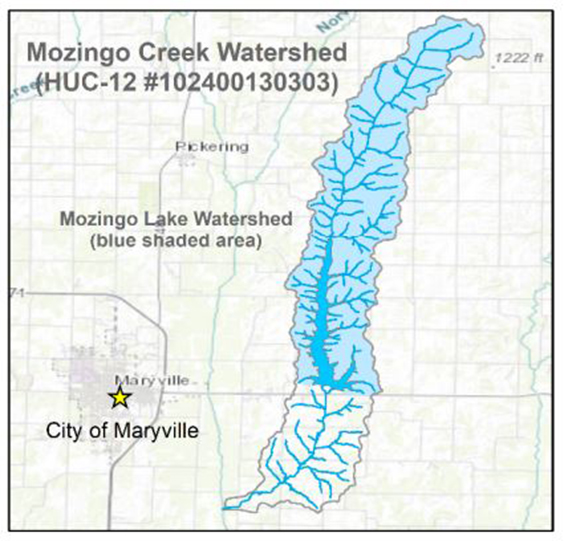
Mozingo Lake is a reservoir that was created in 1994, by damming the Mozingo Creek. Originating about 4 miles south of the Iowa state line, Mozingo Creek is an 8.3 miles long perennial stream. Mozingo Lake is located in the Mozingo Creek 12-digit Hydrologic Unit Code (HUC12) subwatershed (HUC #102400130303). In addition to the 1,006 acre Mozingo Lake, there are 161 small lakes and ponds in the subwatershed ranging from 0.14 to 7.6 acres.
Mozingo Lake is the drinking water supply for the city of Maryville and serves as a major recreational area for waterskiing, boating, swimming and fishing. The 4.2-mile-long reservoir has an average depth of approximately 10.5 feet and a maximum depth of approximately 50 feet. Although Mozingo Lake is located a few miles east of Maryville, the watershed itself is sparsely populated. The Mozingo Lake Recreation Park represents the largest developed area within the watershed.
The watershed area that drains into Mozingo Lake is mainly agricultural, with pastureland (39%) and cropland (37%) making up the largest land uses. Cropland consists of both corn and soybean row crops. Other agricultural land uses, which mainly includes hayfields, winter wheat and alfalfa, make up 7% of the land use. The remaining land uses are forested areas (9.9%) and developed areas (6.9%). Developed areas are predominantly characterized as open space (95%) and low intensity (5% as single-family).
Water Quality Issues
There have been multiple efforts to characterize water quality since the lake was constructed. Two Missouri universities performed long-term monitoring programs. The city of Maryville began its own monitoring program in 2017. Typical of reservoirs in the region, Mozingo Lake is considered eutrophic because it has high levels of nutrients and phytoplankton biomass. These conditions are frequently associated with taste and odor issues and harmful algal blooms (HAB).
In 2020, Mozingo Lake was included on the state’s 303(d) list as impaired for the protection of warm water aquatic life. The impairment was based on elevated levels of chlorophyll-a and total nitrogen and high cyanobacteria counts exceeding the eutrophication factor threshold. The predominant source of nutrients and sediment loading is nonpoint source runoff from agricultural land uses.
In addition to the 303(d) listed impairment, residents have complained about drinking water taste and odor issues due to high levels of geosmin. There have been harmful algal blooms and an overgrowth of aquatic plants at the confluence of Mozingo Creek.
Watershed Management Plan
In 2022, the city of Maryville was awarded a Section 319 Nonpoint Source Program subgrant from the Missouri Department of Natural Resources to fund developing a 9-element watershed-based plan, a Quality Assurance Project Plan and initiate lake sampling. Mozingo Lake is the focus of the watershed plan, since the main concerns are the nutrient and sediment conditions of Mozingo Lake, which caused it to be 303(d)-listed as impaired.
The city voluntarily sponsored the development of the watershed plan and is committed to supporting landowners and other stakeholders to implement the land management best management practices, education and outreach activities and monitoring programs described in the plan. Technical assistance through various local, state and national groups will connect the city and landowners to regenerative land practices, financial assistance opportunities and mentorship programs.
Project Goals
One element of the watershed plan is determining the pollutant load reductions needed to achieve water quality objectives. Total nitrogen, total phosphorus and sediment load reductions were modeled to target compliance with the water quality criteria. While sediment is not part of Missouri’s numeric nutrient criteria standards, it is strongly associated with sediment-bound phosphorus.
| Pollutant | Targeted Watershed Reduction | |
|---|---|---|
| Percent Reduction | Load Reduction | |
| Total Nitrogen | 20% | 15,642 pounds/year |
| Total Phosphorus | 32% | 5,256 pounds/year |
| Sediment | 32% | 3,278 tons/year |
Implementation Measures
- Best Management Practices (BMP) - Each practice was described and vetted through the Mozingo Lake Watershed subcommittee to verify practicable implementation.
- Education and Outreach - Develop an education and outreach program to educate landowners on the current water quality issues, soil and water conservation and management practices that remediate the water quality issues and the tools and resources available to aid in BMP implementation.
- Monitoring Activities - The city will collect both continuous and discrete data at multiple locations throughout the lake and at the Maryville Wastewater Treatment Plant. The monitoring data will be supplemented with data collected by the U.S. Geological Survey.
Best Management Practices
- Cropland Practices: Use grasses, legume, and forbs for seasonal cover crops; build terraces (earth embankment or combination ridge and channel) across the field sloop to reduce erosion, trap sediment and manage water runoff; practice no-till cultivation to reduce erosion, conserve water by reducing evaporation, provide food and cover for wildlife and reduce fuel and labor costs.
- Pastureland Practices: Use permanent fencing to minimize livestock access to streams; prescribed grazing with animals to reduce soil erosion.
- Other Practices: Streambank stabilization to minimize the erosion of streambanks and channels; prairie restoration between fields and surface waters to reduce contaminants in runoff; In-stream constructed wetlands to naturally treat water.
Nothing in this document may be used to implement any enforcement action or levy any penalty unless promulgated by rule under chapter 536 or authorized by statute.
For more information
Section 319 Nonpoint Source Unit
Water Protection Program
Water Pollution Control Branch
P.O. Box 176
Jefferson City, MO 65102-0176
United States
