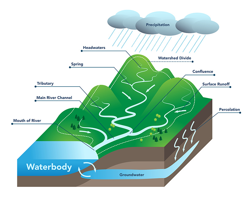
Most of us have seen streams filled to the tops of their banks during storms. But how often do we think about how all that water gets there? When it rains or snow melts, the water either travels across the land (runoff) and into a water body or soaks into the soil (percolation). Water in the soil may be used by plants or it may enter the groundwater system. Groundwater flows like a very slow underground river, often ending up in a nearby stream or other water body.
The area of land that collects the water and drains or "sheds" it into a specific water body is called a watershed. All land is part of a watershed and every creek, stream, river and lake has its own watershed. Watershed boundaries are marked by landscape features that divides the direction of surface water flow, such as hills and ridge lines. It is these features that direct the flow of water.
Just as water bodies exist in various sizes, so do watersheds. Some can be as small as a few city blocks or a farm field, draining into local streams or rivers. Water from hundreds, and often thousands, of creeks and streams will continue flowing downstream, eventually ending up in a larger water body. These larger watersheds, which are essentially groups of smaller watersheds, can cover entire states or regions.
Hydrologic Units
In order to identify and organize our watersheds, the U.S. Geological Survey divided and sub-divided our nation into successively smaller hydrologic units. A hydrologic unit describes the area of land above or upstream from a specific point on a stream that contributes surface water runoff directly to that point. It is defined by a designated starting point, usually the water body's mouth or outlet, and follows the highest elevation of land that divides the direction of the surface water flow, or ridge line, until it connects back to the outlet point. Each unit is assigned a unique hydrologic unit code (HUC) consisting of two to twelve digits, based on the classification level in the hydrologic unit system:
- HUC-2 (Region)
- HUC-4 (Subregion)
- HUC-6 (Basin)
- HUC-8 (Subbasin)
- HUC-10 (Watershed)
- HUC-12 (Subwatershed)
The hydrologic units are arranged or nested within each other, from the largest geographic area (regions) to the smallest geographic area (cataloging units). The larger the HUC number, the smaller the watershed is in scale or size, For more information about hydrologic units, visit USGS' Watershed Boundary Dataset webpage. The Missouri Department of Natural Resources also maintains an interactive Missouri Watersheds map, depicting HUC-8 and HUC-12 watersheds that intersect Missouri.
Importance of Watersheds
We all live in a watershed. Watersheds provide us with water for drinking, recreation, industry processes and irrigation for agriculture. Many people enjoy and use lakes and streams for their beauty, boating, fishing and swimming. Wildlife need healthy watersheds for food and shelter. Lakes, rivers, streams and wetlands are homes for many kinds of animals, insects and plants. A healthy watershed has the necessary structure, or landscape, in place to help maintain the natural flow and fluctuations in water levels in lakes and wetlands. This helps maintain the natural processes, such as sediment deposits and nutrients, necessary for supporting aquatic habitats and biological communities.
Protecting our Watersheds
Water quality is a major concern in a watershed. How we use the land can affect watersheds and the quality of the water resources they provide. Water quality problems can result from a wide variety of activities. If an area experiences more frequent floods or an over-abundance of nutrients, the water quality can be affected, potentially reducing the quantity and quality of an aquatic habitat, harming aquatic life, negatively impact drinking water supplies and possibly result in the loss of an ecosystem.
As we build communities and increase our infrastructure, we add surfaces, such as asphalt and concrete, that do not allow water to soak into the soil. As surface water runoff flows to the nearest water body, it often picks up contaminants that can pollute our waters, such as chemicals and bacteria. Pollution can also occur from factories, wastewater treatment plants or large confined animal feeding operations that discharge into a waterway. Pollution can make water unsafe for humans to drink or swim in and make it difficult for fish and other creatures that live in it to survive or thrive. Much of the focus of the Missouri Department of Natural Resources water quality programs has been on restoring impaired waters and reducing pollutant levels in waterways.
In This Section:
Contact Information
Watershed Protection Section
Water Protection Program
Water Pollution Control Branch
P.O. Box 176
Jefferson City, MO 65102-0176
United States