2233 Cass Ave.
St. Louis, MO 63106
United States
Twenty-seven city blocks within a historic neighborhood in St. Louis will be the new home for the National Geospatial-Intelligence Agency West Campus. An assortment of 551 properties, including a mix of residential and industrial properties dating back to the 1800s, became blighted with contamination from asbestos, household wastes and other contaminants. The 45 million cleanup and $1.7 billion budget to build and furnish the redevelopment project looks to serve as a catalyst for further development in the area.
The site is made up of an assortment of 551 properties, covering 27 city blocks. It is described as the area bounded by Cass Ave. (south), Jefferson Ave. and Parnell St. (west), Montgomery St. (north) and N. 22nd St. (east). Bordering neighborhoods include Hyde Park, Jeff Vanderlou, Carr Square and Old North St. Louis. In the late 1800s, the area was a mix of residential and industrial use properties and individual parcel history varied. Industrial operations have included auto repair stations, dry cleaners, chemical mixing, manufacturing and dry goods stores. The residential properties contained a mix of single-family homes and multi-family complexes.
The area became blighted as residents and businesses relocated through the years. By 2015, very few properties were occupied. The 551 properties were under various ownership and 74% were vacant. The parcels were obtained through purchase, or by the use of eminent domain, to ensure a clean title at the time of transfer to the federal government.
The department's Brownfields/ Voluntary Cleanup Program (BVCP) staff performed many Phase I and Phase II Environmental Site Assessments (ESAs), along with an asbestos-containing materials survey of the properties. The U.S. Environmental Protection Agency's Region 7, Targeted Brownfield Assessment Program performed additional Phase II ESAs and asbestos-containing materials surveys. The site investigations found asbestos and household wastes throughout many of the structures. Soil and groundwater investigation results showed minimal amounts of contamination, mainly related to historical petroleum use and urban fill materials common to the St. Louis area. Other issues identified were historic automotive fueling and repair facilities, historic dry cleaning facilities, historic metallizing and electroplating facilities, underground storage tanks, scrap yards, buried demolition debris, buried or dumped solid waste and impacted urban fill. These issues caused soil contaminated with lead, arsenic, polycyclic aromatic hydrocarbons (PAHs), petroleum compounds, chlorinated solvents and groundwater contaminated with chlorinated solvents.
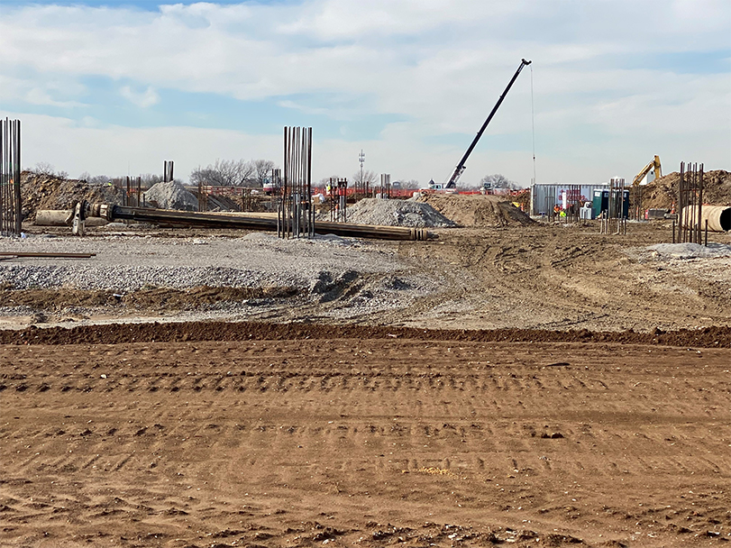
In August 2017, remediation began to remove buried construction and demolition waste, contaminated soil and 20 underground storage tanks. The site remediation work was completed in Fall 2018, bringing the site to residential use qualifications. Site remediation included the following activities:
- Confirmation soil sampling for lead, arsenic and PAHs at all properties, including residential lots with no prior history of environmental concern. The sampling event included collecting over 5,800 environmental samples.
- Surface soil exceeding the screening level, but below residential subsurface risk-based target levels, was cut and reused on-site as deep fill.
- Removing 835,516 tons of construction and demolition waste and impacted soils, along with 200 tons of lead impacted hazardous waste soils.
- Placing a clean fill cap at least three feet deep across the site to eliminate direct contact to subsurface soil.
- Abating and removing 137 structures, along with 31,000 cubic yards of streets and alleys, 37,824 linear feet of curbs, 18,984 linear feet of sewer lines, 12.95 miles of gas and water lines, 13 miles of overhead lines and relocating one structure.
As of 2020, work on the site has been mainly grading, mapping and installing site utilities such as water, electrical and sewer.
Funding Sources
- Brownfield Tax Credits
A large-scale construction project will result in the new home for the National Geospatial-Intelligence Agency West Campus. As a member of the St. Louis community for more than 70 years, the National Geospatial-Intelligence Agency is committed to preserving and enhancing the history of the area. The National Geospatial-Intelligence Agency is working to design the new campus in a way that will make it a good fit for the community. This $1.7 billion project is managed by the U.S. Army Corps of Engineers and executed by McCarthy HITT Joint Venture, with oversight by the National Geospatial-Intelligence Agency and the U.S. Air Force. The west campus’ construction goals are to include 25% minority-owned and 5% woman-owned businesses for subcontractor participation, and 15% minority-owned and greater than 5% woman-owned businesses for individual workforce participation.
Project Partners
- BVCP Project Managers
- U.S. Army Corps of Engineers
- Castle Contracting
- National Geospatial-Intelligence Agency
- City of St. Louis
- St. Louis Development Corp.
- Missouri State Historic Preservation Office
- HITT Contracting
- U.S. Air Force
The project serves as a catalyst for further development in the area. The new facility highlights include the following:
- Five-year, $1.7 billion construction project
- 1,300 construction workers on-site during peak activity periods
- Approximately 3,150 National Geospatial-Intelligence Agency employees
- Retaining $2 million per year in tax revenue for the City of St. Louis
- Potentially 1,900 new federal jobs
- Expected 100 year life span of the new building
Institutional Controls
- Soil management plan to direct future property development activities that may disturb the clean fill cap
- Activity use limitation and local ordinance preventing use of groundwater
BVCP Project Identification
- SMARS #12577
Assurances Received
- November 2015 - Letter of Agreement Received
- October 2018 - Certificate of Completion Issued
Contact Information
Brownfields/ Voluntary Cleanup Program
Environmental Remediation Program
P.O. Box 176
Jefferson City, MO 65102-0176
United States