Urban and rural stormwater runoff contribute to water quality impairments in South Creek, a tributary of Wilsons Creek. Various biological studies conducted in 1989 through 2009 in the watershed showed low aquatic macroinvertebrate populations and diversity due to unknown toxicity. Ecological restoration efforts conducted on a 1-mile segment of South Creek greatly improved aquatic life habitat and aquatic macroinvertebrate populations inhabiting the stream. Work within the Wilsons Creek watershed, including in South Creek, has focused on improving the riparian corridor, streambanks and instream habitat conditions. Monitoring results showed the health of the aquatic macroinvertebrate populations improved, with the greatest improvements occurring along the restored reach of South Creek.
Problem
The 10.5-square-mile South Creek subwatershed drains a high-density urban area with approximately 25% impervious cover (Figure 1). It empties into Wilsons Creek (Waterbody ID 2375), which flows west and south and drains much of the city of Springfield (population 165,000) in southwest Missouri. Wilsons Creek joins the James River about 8 miles south of Springfield and is one of the largest tributary streams in the James River system. Figure 1. South Creek is in the Wilsons Creek watershed.
In the 1970s, South Creek was a popular fishing location. However, by the mid-1980s, the 1-mile stretch between Campbell Avenue and Kansas Expressway along Sunset Street was converted to a concrete channel. Expanding urban development in Springfield increased stormwater runoff into South Creek, which contributed to the water quality impairments in Wilsons Creek and the James River.
Toxicity testing of waters by the National Park Service in 1989 found toxicity in both Wilsons Creek and South Creek. Sampling data showed that Wilsons Creek had a low diversity of aquatic macroinvertebrates and fish due to unknown toxicity; as a result, Missouri added Wilsons Creek to the Clean Water Act section 303(d) list of impaired waters list for unknown toxicity (1998), polycyclic aromatic hydrocarbons in sediment (2014) and Escherichia coli (2006). The impaired designated uses are for protection of warm water aquatic life and whole body contact level B. Although South Creek is not listed as impaired, its poor water quality has contributed to problems downstream in Wilsons Creek.
Story Highlights
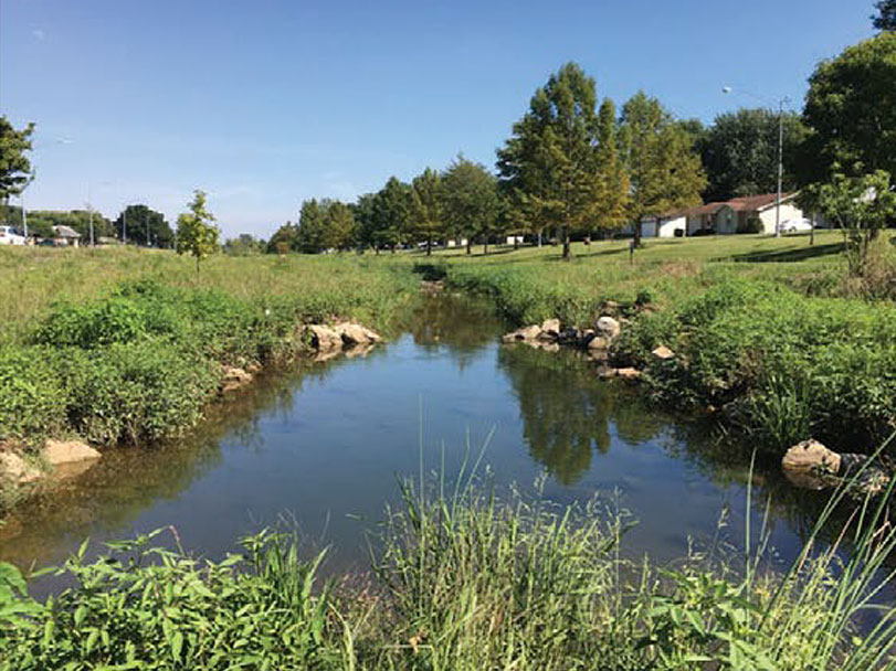
The one-mile stretch of South Creek was restored to a natural condition by removing the concrete channel and redesigning a meandering channel with pools, riffles, rocks and logs typical of an Ozarks stream (Figure 2). This stretch of South Creek is now a place where native plants naturally filter storm water and provide habitat for a variety of terrestrial and aquatic animals. The project was implemented as part of the Middle James River Watershed-Based Plan to improve water quality and habitat for aquatic life and facilitate in-stream pollution attenuation through natural physical and biological processes. Specific project accomplishments included removing 1.2 acres of concrete from the stream channel, installing 14 hardwood log weirs and nine Newbury weirs to create instream riffle and pool habitats, installing low flow channels that cut through the floor of reinforced concrete boxes to allow for stormwater infiltration, adding 115 tons of creek rock and 65 boulders for aquatic habitat, creating 40 vegetated rain garden treatment areas to capture and infiltrate stormwater runoff, seeding 8 acres with a mix of 30 native plants and 103 native trees along the 60-foot-wide riparian corridor, and adding educational signage along the South Greenway Trail that highlights project efforts and the water quality and habitat benefits achieved.
Ongoing efforts within the Wilsons Creek watershed focus on improving the aquatic life designated use by reducing impacts from urban runoff and preserving and restoring the riparian corridor, streambanks, and instream habitats.
Results
Biological assessments of South Creek were conducted before (2014–2015) and after (2017–2020) stream restoration efforts were completed. Five sites were monitored to document changes in the aquatic macroinvertebrate community, including one upstream, three along the restored project reach, and one downstream. The results showed that the health of the aquatic macroinvertebrate populations improved from poor-fair to good-excellent, with the greatest improvements occurring within the restored reach. The improved ratings were due to increases in diversity and richness of aquatic organisms after restoration
Water quality modeling estimated a 15% load reduction for both total nitrogen and total phosphorus, as well as a 29% load reduction for sediment. These load reductions are incremental steps towards reducing the frequency of algal blooms in excess of 100 milligrams per square meter (mg/m2 ) and meeting the nutrient target recommendations in the James River total maximum daily load (0.075 milligrams per liter [mg/L] total phosphorus and 1.5 mg/L total nitrogen) which apply to all classified streams that drain into impaired segments of the James River.
Partners and Funding
Key project partners included the City of Springfield, Olsson, James River Basin Partnership, Ozark Greenways (OG), Missouri State University, U.S. Environmental Protection Agency, Missouri Department of Natural Resources, and Missouri Department of Conservation (MDC). The total cost of the South Creek project was $1,298,427 and consisted of the City’s match of $533,283; $144 in-kind from OG and the $765,000 CWA section 319 grant. Specific costs for design and construction were $144,638 and $1,088,010; respectively. The required 40% match of $514,795 was provided through the ¼-cent Capital Improvements Sales Tax and the 2006 Springfield–Greene County Parks/Waterways Sales Tax, in-kind staff time, and a $10,000 MDC Community Conservation Grant.