Missouri Geological Survey Director: Carey Bridges, RG
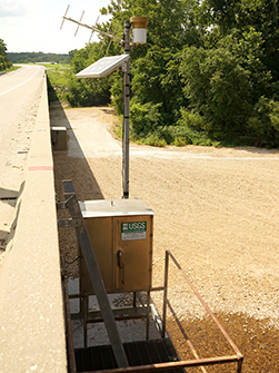
The Huzzah Creek streamgage below Steelville is owned by the U.S. Geological Survey (USGS) and funded in cooperation with the Missouri Department of Natural Resources. Stage (water-surface elevation) measurements are made and recorded at 15-minute intervals and transmitted to the USGS office every hour. Stage and streamflow values are displayed in near real-time.
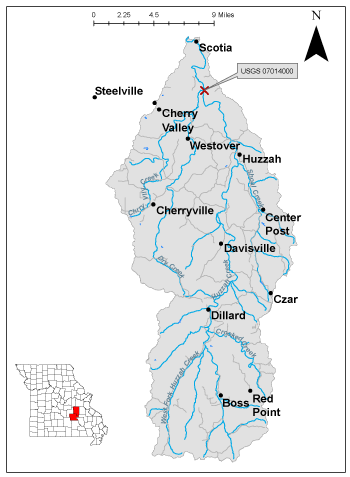
Huzzah Creek is a stream in Missouri’s Ozark Highlands, flowing into the Meramec River. The headwaters originate in northern Reynolds County. The name is derived from one of the many of the names given to the Osage people by French explorers (Zimmer).
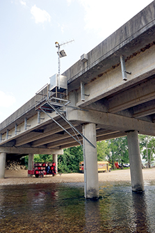
The streamgage is located at the State Highway 8 bridge over Huzzah Creek near Huzzah Valley Resort, nine miles east of Steelville in Crawford County and consists of a shelter, a data collection platform, a rain gauge, an electronic pressure transducer to measure stage, a crest stage gage to automatically record crest height during high water events and a wire weight gage used to manually verify electronic measurements. Learn how a USGS streamgage works.
Streamgage Information
- Streamgage Drainage Area: 259 square miles
- 10-Digit Hydrologic Unit Code: 0714010204
- Area of HUC10 Basin: 267 square miles
- Gage Location: 37°58'29", -91°12'16" (NAD27) (Crawford County)
- Gage Datum: 665.04 feet above NAVD88
USGS Tools
- Maximum, Minimum, Average Water Temperature: Nov. 10, 2010 to present
- Average Discharge (cubic feet per second): March 5, 2007 to present
- Observation Gage Height (feet): March 6, 2007 to present
- Peak: Gage Height, Discharge (feet, cubic feet per second) 16.8, 33,300 (April 29, 2017)
The Huzzah Creek near Steelville streamgage webpage is maintained by USGS. Users are able to create graphs and tables utilizing the recorded parameters, which can be customized to show current and historical observations, daily data, daily statistics, monthly statistics, annual statistics, peak streamflow and field measurements for any time frame within the period of record. A location map and Water-Year Summary also are available. Customize your own data output online.
Why is the Huzzah Creek Streamgage near Steelville Important?
The streamgage provides recreational users in the area, surrounding landowners, and the public with accurate stream height data. The Department’s Water Resources Center uses discharge data from this streamgage for flood, drought and water supply studies. This stream is considered one of the best floating rivers in Missouri (Riverfront).
In the area, people can enjoy:
- Bird-watching
- Camping
- Fishing
- Floating and Canoeing
- Horseback riding
- Hiking
- Picnicking
For more information about recreation activities located within the basin, contact the Missouri Department of Conservation.
|
|

|
P1010627.jpg
Figure 3. Site profile.
P1010620.JPG
Figure 4. Gage antenna and rain gauge.
1010621.jpg
Figure 5. Wire weight gage.
P1010625.jpg
Figure 6. Channel detail.
1 REFERENCES CITED
Best River for Float Trips: Huzzah Creek.
Zimmer, Gertrude M. "Place Names Of Five Southeast Counties Of Missouri." M.A. thesis., University of Missouri-Columbia, 1944.
Nothing in this document may be used to implement any enforcement action or levy any penalty unless promulgated by rule under chapter 536 or authorized by statute.
For more information
Water Resources Center
Missouri Geological Survey
P.O. Box 176
Jefferson City, MO 65102-0176
United States