Division of Environmental Quality Director: Art Goodin

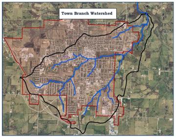
Town Branch, which encompasses over 3,800 acres, is predominately located within the city limits of Bolivar, Missouri. Town Branch drains into the Piper Creek 12-digit Hydrologic Unit Code (HUC12) subwatershed (HUC #102901070303), which drains into the larger Pomme de Terre River HUC10 watershed. The Piper Creek subwatershed encompasses 23,751 acres of Polk County in southwest Missouri.
Land use in the Piper Creek subwatershed is a mix, but is mainly rural: pasture/ hay (63%), forest/ shrub (18%), cropland (4%) and water and wetland (1%), developed/ city of Bolivar (14%). Town Branch is part of the Piper Creek subwatershed and is predominately made up of commercial and residential land uses, with 67.6% identified as urban land cover.
Water Quality Issues
Urbanization increases the variety and amount of pollutants carried into streams, rivers and lakes, which can severely impairs water quality and quantity conditions. Such conditions include increased nutrient and bacteria levels, stream bank erosion, heavy metal contamination, trash accumulation and flooding events. Piper Creek was first listed on the state's 303(d) list of impaired waterbodies in 2008, due to high levels of organic sediment. The area of impairment begins on the southern Town Branch section starting from Springfield Ave. and flowing into Piper Creek. This impairment continues for the duration of Piper Creek (approximately 7.5 miles) until its confluence with the main stem of the Pomme de Terre River.
In 2010, the Piper Creek-Town Branch Total Maximum Daily Load (TMDL) was established in order to address the sources of impairment. The pollutants identified and subsequently addressed in the TMDL are nutrients (total phosphorus and total nitrogen), sediment (total suspended sediment) and low dissolved oxygen.
Watershed Management Plan
In 2012, the Bolivar Community Watershed Improvement Group completed a Town Branch Watershed Management Plan, which was reviewed in 2020. The purpose of this plan is to identify and address nonpoint source pollution. Such areas include runoff from agriculture and urban areas, on-site wastewater systems and degraded channel and riparian conditions such as stream bank erosion. This watershed plan serves as a guide to improve and sustain the water quality resources of Town Branch and Piper Creek.
Project Goals
The goals of the Town Branch watershed plan are to:
- Restore and enhance water quality conditions of the watershed in order to improve and sustain the quality of life for the Bolivar and Polk County area.
- Identify and address sources of nonpoint source pollution
- Guide future implementation of voluntary conservation practices funded by Missouri’s nonpoint source pollution program (§319)
The objectives of the Town Branch watershed plan are to:
- Implement the TMDL for Town Branch-Piper Creek
- Promote agricultural best management practices (BMPs) and cost share assistance programs
The pollutants of concern addressed in the plan include total nitrogen, total phosphorous and total suspended solids. The plan outlines BMPs for implementation across a variety of critical areas, including; riparian, urban, residential, undeveloped and agricultural areas. This leveraging project focused specifically on implementation of agricultural BMPs.
Best Management Practices
Below is a summary of recommended practices as provided in the Town Branch Watershed Plan.
- Livestock BMPs: rotational grazing, livestock exclusion with alternative watering, pasture enhancement/ management
- Cropland BMPs: nutrient management, field borders
- Streambank BMPs: streambank stabilization, riparian buffer establishment, timber stand improvement
Nothing in this document may be used to implement any enforcement action or levy any penalty unless promulgated by rule under chapter 536 or authorized by statute.
For more information
Section 319 Nonpoint Source Unit
Water Protection Program
Water Pollution Control Branch
P.O. Box 176
Jefferson City, MO 65102-0176
United States

