Division of Environmental Quality Director: Art Goodin

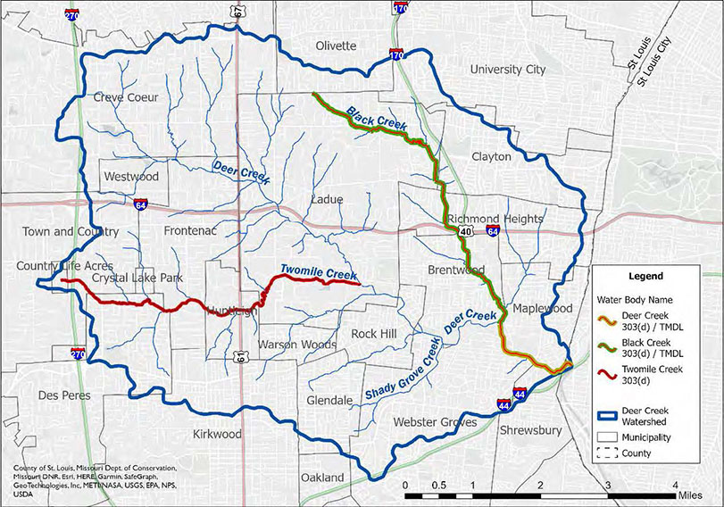
Deer Creek is an urban stream in St. Louis County and western St. Louis. Originating in north central Creve Coeur, Deer Creek flows southeast for about 10.75 miles before entering the River des Peres in St. Louis. The Deer Creek watershed drains about 36.8 square miles and intersects 23 municipalities. The major contributing streams within the watershed are Deer Creek, Black Creek, Twomile Creek, Sebago Creek and Shady Grove Creek. Black Creek originates in north Ladue and flows south for 5.6 miles until it joins Deer Creek, forming the municipal boundary between the cities of Brentwood and Maplewood. The Deer Creek 12-digit Hydrologic Unit Code (HUC12) subwatershed (HUC #071401010504) is one of 14 subwatersheds that make up the Prairie duPont Creek-Mississippi River HUC10 watershed.
Approximately 99% of the Deer Creek watershed is developed land: high intensity development (6.4%), medium intensity development (9.1%), low intensity development (56.9%) and developed open space (27%). Land use in the remaining 1% of the watershed is a mix of forest, wetland and open water.
Water Quality Issues
Land use contributes to different water quality concerns or benefits in a watershed. Major water quality threats in the Deer Creek watershed derive from stormwater runoff over impervious surfaces. Developed areas tend to have more paved surfaces, which prevents the ground from absorbing precipitation from rainfall or snowmelt. According to the Metropolitan St. Louis Sewer District, actual imperviousness of the Deer Creek watershed, or inability for water to absorb into the soil, is approximately 33%. This is significant, because stream degradation associated with imperviousness has been shown to first occur at about 10%, and increase in severity as imperviousness increases.
Impervious surfaces drain rainwater from overland into storm drains that carry it directly to the streams. In general, urban runoff carries high levels of bacteria and other nonpoint source pollution that may result in exceedances of water quality criteria during and immediately after storm events. In 2020, Deer Creek and its tributary, Black Creek, were listed on the state's 303(d) list of impaired waterbodies for chloride. Twomile Creek was also listed for E. coli. River des Peres, which receives waters from Deer Creek, was also identified as impaired for E. coli and chloride. River des Peres was originally listed as impaired in 2009 for low dissolved oxygen and chlorides, but was no longer identified as impaired due to low dissolved oxygen in 2020.
Numerous studies have been conducted in the Deer Creek watershed, dating as far back as 1963. In 2019, the Black Creek and Deer Creek Total Maximum Daily Load (TMDL) was approved to address E. coli (pathogens) for the lower 1.6 miles of Deer and Black creeks. A TMDL is currently under development to address chloride in Black Creek and Deer Creek, prioritized as high and scheduled for 2025. A TMDL to address E. coli in Twomile Creek is being prioritized as medium and is scheduled for 2026-2030.
Watershed Management Plan
In April of 2008, a group of citizens concerned about Deer Creek formed a Creeks Committee and approached Missouri Botanical Garden to sponsor their work. Missouri Botanical Garden agreed, provided the scope of the project included the entire Deer Creek Watershed. A 9-element Watershed plan was developed during Phase 1 of the Deer Creek Watershed Initiative, which the department accepted in 2011. The current Deer Creek Watershed Management Plan was developed by the Missouri Botanical Garden's Deer Creek Watershed Alliance and accepted by EPA in February 2023. The plan was created to help improve and protect water quality in the watershed by identifying best management practices (BMPs) to be implemented to help address the stream bacteria impairment and other pollutants to improve the water quality of Deer Creek.
Project Goals
The goals for the Deer Creek watershed are also listed in Chapter 9 with interim measurable milestones. Chapter 10 provides specific, time-sensitive performance criteria which can measure progress towards each goal.
- Maintain and improve water quality and quantity in watershed related to a one-year storm event or less
- Capture the first 1.14 inch of rainfall in rainscaping projects to reduce primary and secondary pollutants of concern
- Reduce additional identified pollutant inputs
- Reduce the risk of stream bank erosion, sedimentation and flooding from a one year or greater storm event
- Maintain and improve the natural physical stability of the stream and reduce stream widening and bank erosion
- At least 2,000 linear feet or 10 acres of riparian corridor restored and appropriately landscaped to reduce impacts on erosion, sedimentation and creek widening by 2040
- Protect groundwater supplies in sensitive karst areas
- Finalize EPA accepted watershed plan updates in 2022 and in 2027
- Expand and improve watershed modeling efforts
- Continue and refine watershed monitoring efforts
- Continue ongoing planning and implementation efforts
Best Management Practices
Deer Creek Watershed Alliance has identified 11 BMPs that reduce stormwater runoff, mainly by improving soil permeability through rainscaping. These eleven rainscaping BMPs are:
- Native soil rain gardens
- Engineered bioretention systems or rain gardens
- Bioswales
- Creek corridor vegetative buffer or riparian corridor restoration
- Lawn alternatives
- Woodland restoration
- Green roofs
- Permeable pavers
- Soil amendments
- Filter sock and rock weirs
- Rainwater harvesting
Since the Deer Creek Watershed Initiative planning efforts began, 466 BMP installations have been completed in the watershed as if 2021, currently resulting in load reductions of 187.5 tons of sediment, 109 pounds of nitrogen and 21.5 pounds of phosphorus per year from Deer Creek.
Nothing in this document may be used to implement any enforcement action or levy any penalty unless promulgated by rule under chapter 536 or authorized by statute.
For more information
Section 319 Nonpoint Source Unit
Water Protection Program
Water Pollution Control Branch
P.O. Box 176
Jefferson City, MO 65102-0176
United States