Division of Environmental Quality Director: Art Goodin
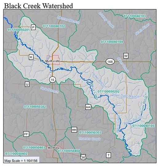
The Black Creek watershed encompasses 34,484 acres in Shelby County, in northeast Missouri. Black Creek watershed is one of several smaller watersheds that make up the North Fork subbasin of the Salt River basin. The major streams within the Black Creek watershed are Baker Branch (4.82 miles), Oak Dale Branch (4.46 miles) and Parker Branch (3.37 miles), which empty into Black Creek (26.74 miles). Land use in the watershed is a mix, but is mainly agriculture: cropland (47%), pasture/ hay (30%), forest (12%), developed (5%) and water and wetland (4%).
Water Quality Issues
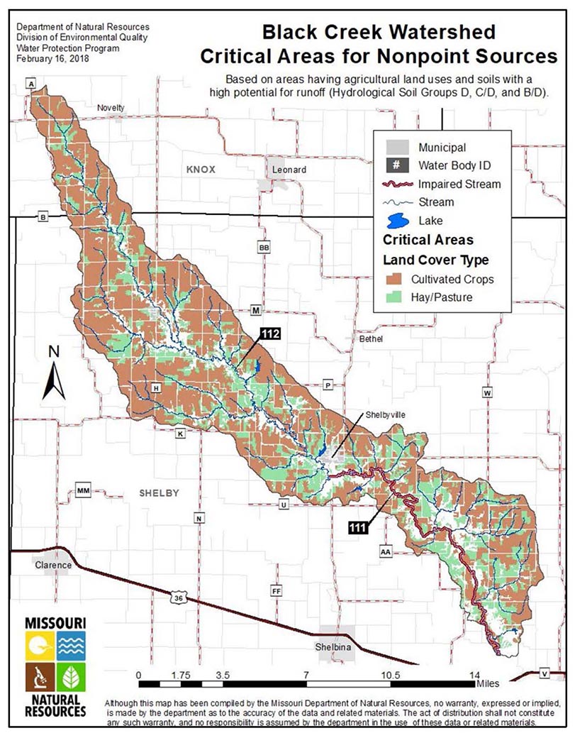
Black Creek is included on the state’s 303(d) list as impaired for E. coli. Shelbyville Lake, located within the Black Creek watershed, is listed as impaired for Chlorophyll-a. Both water quality problems are due to nonpoint source pollution. The most likely nonpoint sources are sediment from eroding crop and grazing lands and excess nutrients from agricultural runoff, which can contribute to the overgrowth of nuisance algae. About 97% of the land within the watershed has low to very low infiltration rates when thoroughly wetted, which impedes downward water movement, resulting in a high runoff potential. Black Creek is a tributary of the north fork of the Salt River, which is part of the Mark Twain Lake watershed. Mark Twain Lake is the drinking water source for 14 counties in northeast Missouri, providing three million gallons of drinking water daily.
Watershed Management Plan
In 2018, a 10-year watershed-based plan for the Black Creek watershed was completed. The Black Creek Watershed-based Plan outlines the restoration and protection goals and actions for surface waters in part of the watershed. Although the watershed includes two 12-digit Hydrologic Unit Code (HUC12) subwatersheds, this plan only targets the Black Creek HUC12 (HUC #071100050202). The plan development process involves the local community (producers and landowners) and governmental agencies working together toward the common goal of a healthy environment. Local participants provide valuable grass roots leadership and responsible resource management. State and federal agencies support watershed restoration and protection efforts by working with local communities to build awareness, provide public information and education, engage local leadership in monitoring and evaluating watershed conditions and planning and implementing the watershed based plan.
The Black Creek watershed steering committee, consisting of stakeholder, landowners and producers from a variety of backgrounds, was instrumental in guiding the planning project. The committee provided valuable information on such things as land use issues as well as feedback, evaluating and prioritizing uses, concerns, best management practices (BMPs), goals, objectives and other important components of the actual management plan. The steering committee felt 10 years would provide enough time to secure funding and allow the plan goals to be met.
Project Goals
The overall goal of the Black Creek watershed plan is to provide a sustainable water source for recreational and domestic use while preserving food and fiber production. Specifically, the goal is to reduce sediment loading by 50% and nutrient loading by 60%. The goal for E. coli is to reduce bacteria levels to Class B recreational water quality standards. That goal is no more than 206 colonies/ 100 ml between April 1 and October 31. This will be achieved by using a holistic approach by promoting BMPs that reduce the amount of sediment (50%), phosphorous (30%) and nitrogen (30%) that reach the stream.
Implementation Measures
Implementation measures proposed to be used to achieve these goals include the following:
- Increase adoption of residue and tillage management
- Cover crops and conserve crop rotations to reduce sediments and nutrients in runoff
- Stabilize eroding gullies
- Use nutrient management to match fertilizer addition to crop need
- Promote using precision agriculture techniques to apply nutrients
- Promote using prescribed grazing systems
- Develop and encourage adoption of a plan to address all resource concerns with the latest technology
- Use BMPs at the tract level
- Promote establishing permanent vegetation and improve wildlife habitat
- Implement a general information campaign to increase awareness of nutrient management issues in Black Creek
- Develop a long-range monitoring program with clearly defined milestones that will measure beneficial use support in the watershed
The BMPs that will be implemented to help achieve these goals include terraces, nutrient management, filter strips, field borders, cover crops, grass waterways, reduced tillage, interseeding, stream exclusion, woodland protection and alternate water sources.
Nothing in this document may be used to implement any enforcement action or levy any penalty unless promulgated by rule under chapter 536 or authorized by statute.
For more information
Section 319 Nonpoint Source Unit
Water Protection Program
Water Pollution Control Branch
P.O. Box 176
Jefferson City, MO 65102-0176
United States