Division of Environmental Quality Director: Art Goodin

The Meramec River is one of the longest free-flowing rivers in the United States, stretching over 200 miles from its headwaters southeast of Salem, Missouri in Dent County, to the Mississippi River in St. Louis County. The main stem of the Meramec carries water from the lightly populated, forested and agricultural upper watershed, north easterly to the heavily populated and urbanized lower watershed. Within the Meramec River basin, the lower Meramec River extends 109 miles, from Meramec State Park in Sullivan, Missouri, to the Meramec River/ Mississippi River confluence in Arnold, Missouri. In recent years, urban development in the lower Meramec has reduced the size of contiguous forest tracts.
Water Quality Issues
Several tributary streams, one lake and two sections of the Meramec River are included on the state’s 303(d) list as impaired, or not meeting water quality standards protecting specific uses. The tributary streams and lake include Antire Creek, Fenton Creek, Fishpot Creek, Fox Creek, Grand Glaize Creek, Kiefer Creek, Mattese Creek, Williams Creek and Bee Tree Lake. These water quality problems are largely the result of nonpoint source pollution. Point sources of pollution from wastewater treatment plants and industries have been regulated and require permits to discharge into receiving waters. These permits specify effluent limits so the discharge still allows the receiving waters to meet water quality standards. Nonpoint sources are mostly stormwater runoff from urban development. Past development practices that were not subject to the permitting process and failing on-site wastewater treatment systems (septic systems) are major contributors of pollutants. The Lower Meramec River remains a prime recreational asset for the region, and water quality improvement and protection are critical to maintaining this resource.
Watershed Management Plan
In 2012 the East-West Gateway Council of Governments completed a Lower Meramec Watershed Management Plan, which provides a framework for maintaining and improving water quality in the lower Meramec River and its tributaries in Franklin and Jefferson counties. The plan covered four 12-digit Hydrologic Unit Code (HUC12) watersheds between the cities of Pacific and Valley Park, which includes Brush Creek, Fox/ LaBarque creeks, Hamilton/ Kiefer creeks and Grand Glaize/ Fishpot/ Williams creeks. In 2017, the plan was updated, adding two more HUC12 watersheds, Sugar/ Fenton creeks and Pomme/ Mattese creeks, located in St. Louis County.
Kiefer Creek
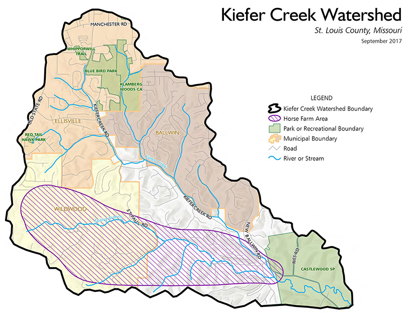
The 2012 plan recommended that Kiefer Creek and other tributaries would each require specific watershed-based management plans. Kiefer Creek is a direct tributary to the lower Meramec River, draining approximately 6.7 square miles of surface area in St. Louis County, west of the city of St. Louis. Kiefer Creek sits within the Hamilton HUC12 subwatershed (HUC #071401021001), which sits inside the Meramec subbasin. Land use in the project area is forest (54%) and developed (41%) with a small amount of grassland/ pasture/ hay (5%). The developed areas are mainly low density (37%), medium density (31%) and open space (23%), with a small amount of high intensity (6%). Kiefer Creek is located within the Outer Ozark Border Subsection Ecoregion, which is characterized as being ecologically diverse, and having numerous occurrences of state-listed rare, threatened and endangered species, despite the lingering threat of urban encroachment. Much of the area (>50%) is now comprised of residential lots and infrastructure, causing increased peak flows and reduced time of concentration.
Specific Issues
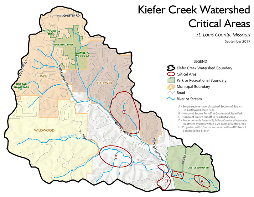
Kiefer Creek was identified as a priority tributary due to its identification through local analysis as a key source of pollution and habitat decline, as well as the fact that it flows through Castlewood State Park – the second most visited State Park in Missouri. Children, adults and pets all can be found wading in the creek near the park entrance, just a quarter mile upstream from its confluence with the Meramec River. Approximately 7,500 feet of the 8,000 feet of Kiefer Creek within the project area is managed by Castlewood State Park, under the authority of the Missouri Department of Natural Resources' Missouri State Parks system. The remaining 500 feet is bounded on one bank by the Wildlife Rescue Center property. Of the total surface drainage area, Castlewood State Park comprises approximately 8.4% by area.
Kiefer Creek is included on the state’s 303(d) list as impaired for E. coli due to rural nonpoint source pollution. The impaired section of the stream extends 1.2 miles upstream from the mouth of the creek where it meets the Meramec River. Most of the bacteria impaired section lies in Castlewood Park and the Wildlife Rescue Center area.
Project Goals
The overall goal of the Lower Meramec River (Kiefer Creek) watershed plan is to reduce bacteria loading in Kiefer Creek by 38.8% to meet water quality standards by 2038. Management measures and projects to achieve the water quality goal include the following:
- Restore the riparian corridor of Kiefer Creek to enhance its ecological functions associated with reducing sediment loads and filtering pollutants
- Expand the use of rainscaping best management practices (BMPs) throughout the Kiefer Creek Watershed to treat stormwater at its source
- Mitigate on-site wastewater treatment system discharges
- Reduce runoff from agricultural property
Below is a summary of practices and the anticipated load reductions or removal efficiencies that will be obtained by installing the BMPs as provided in the Lower Meramec (Kiefer Creek) watershed-based plan.
- On-site wastewater treatment system management measures: Includes connecting to the Metropolitan St. Louis Sewer District collection system or replacing or repairing on-site wastewater systems. Estimate 50% reduction in bacteria load.
- Manure management measures: Manure management techniques or implemented for the commercial stables and residential parcels with horses in the sub-watershed. Estimate a 30% reduction in bacteria load.
- Riparian buffer and stream channel stabilization management measures: Protecting and improving riparian buffer along Kiefer Creek resulting in a passive bio-filter for remaining urban overland runoff and further reduce nonpoint source bacteria loads from wildlife and pet waste. Estimate a 50% reduction in bacteria load.
- Stormwater BMPs measures (Rainscaping): Includes installing bioretention, vegetated swales, native soil rain gardens and pervious pavements.
Nothing in this document may be used to implement any enforcement action or levy any penalty unless promulgated by rule under chapter 536 or authorized by statute.
For more information
Section 319 Nonpoint Source Unit
Water Protection Program
Water Pollution Control Branch
P.O. Box 176
Jefferson City, MO 65102-0176
United States