For over a century, Missouri has been, and continues to be, one of the leading national producers in lead. The Tri-State Mining District, located in southwest Missouri, southeast Kansas, and northeast Oklahoma, was historically one of the nation’s largest lead and zinc mining districts. The Missouri portion of the mining district is located mainly in Jasper and Newton counties, with some mines in Lawrence and Barry counties.
Mining in the Missouri portion of the Tri-State Mining District began in the mid-1800s and continued until 1957. Zinc and lead were the main ores produced. Mines in the area were relatively small and were often operated by small independent companies. Ores were milled and smelted either onsite by the miners themselves or were sent to any of the dozens of mills and smelters operating across the region. For more information about the history of lead mining in Missouri, visit Lead in Missouri.
Environmental Issues
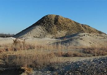
The distribution of small independent mines, mills and smelters scattered throughout Jasper and Newton counties resulted in over 10,000 acres of mine waste and contaminated land, and many miles of contaminated streams. The Missouri portion of the Tri-State Mining District includes two National Priorities List (NPL) Superfund Sites: Newton County Mine Tailings and Oronogo-Duenweg Mining Belt. Mine waste cleanup activities began in 2007 in Jasper County, and in 2014 in Newton County, and are ongoing in both counties.
Restoration activities are part of the ongoing Natural Resource Damage Assessment and Restoration (NRDAR) process under the Comprehensive Environmental Response, Compensation and Liability Act (CERCLA), commonly known as Superfund. The contamination in the Tri-State Mining District caused widespread ecological injury to terrestrial and aquatic habitats, persisting over decades. Ecologically, much of the mining district is situated within the Springfield Plateau ecoregion and within the Spring River watershed. Natural Resource Damage Assessments have shown heavy metal contamination affecting terrestrial and aquatic life that depend on the impacted habitats.
Trustees and Funding
Trustees
Under federal law, the State of Missouri acts on behalf of Missouri's citizens as a trustee for the state’s natural resources. The Governor of Missouri designated the Director of the Missouri Department of Natural Resources as the state natural resource trustee. The federal trustees for the Tri-State Mining District are the U.S. Department of Interior, represented by the U.S. Fish & Wildlife Service.
Restoration Funding
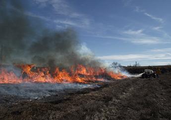
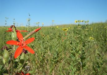
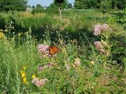
The Tri-State Mining District Trustees recovered monetary damages to use in restoring impacted natural resources and ecological services throughout the Missouri portion of the Tri-State Mining District. Many of the Trustees’ restoration projects are focused on preserving existing native prairie or using restoration based approaches to recreate the tallgrass prairie habitats that once dominated much of the landscape of southwest Missouri.
Restoration Plan
The Trustees began coordinated assessment and restoration activities in 1999. According to CERCLA requirements, the Tri-State Mining District Trustees published the Springfield Plateau Regional Restoration Plan and Environmental Assessment in 2018, to describe the kind of projects to be implemented in the Missouri portion of the Tri-State Mining District, using funds recovered from responsible parties. This document serves as an Environmental Assessment, as well as a Regional Restoration Plan. The Environmental Assessment is designed to consider alternatives that restore, replace, rehabilitate or acquire the equivalent to the natural resources and services injured by the release of hazardous substances in the Tri-State Mining District. The plan also serves to involve the public in the restoration plan, as well as comply with environmental requirements.
For information about any upcoming events, public notices and opportunities for public comment relating to this region, visit What's New in NRDAR.
Projects
For information about any upcoming events, public notices and opportunities for public comment, visit What's New in NRDAR.
Cardinal Valley Habitat Restoration
Restoring mine scarred lands in Webb City into prairie, wetland and woodland habitats.
Joplin Parks Pollinator Prairies
Native prairie reconstruction projects to improve habitat in Joplin city parks.
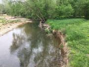
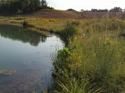
Spring River Riparian Restoration
Riparian projects to help restore the Spring River watershed.
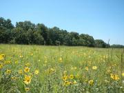
Upland Native Prairie Restoration
Restoring and protecting native prairie remnants throughout southwest Missouri.
Contact Information
Natural Resource Damage Assessment and Restoration
Environmental Remediation Program
P.O. Box 176
Jefferson City, MO 65102-0176
United States