Missouri Geological Survey Director: Carey Bridges, RG
The Big Spring streamgage near Van Buren is owned by the U.S. Geological Survey (USGS) and funded in cooperation with the Missouri Department of Natural Resources. Stage (water-surface elevation) measurements are made and recorded at 15-minute intervals and transmitted to the USGS office every hour. Stage and streamflow values are displayed in near real-time.
Named for its size, Big Spring is a spring in Missouri’s Ozark Plateau and is one of the biggest springs in the country. Its spring branch flows into the Current River about three miles south of Van Buren.
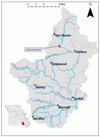
The streamgage is located next to a bridge 600 feet from the mouth of Big Spring near Van Buren in Carter County and consists of a shelter, a data collection platform, an electronic pressure transducer to measure stage and a staff gage used to manually verify stages. Learn how a USGS streamgage works.
Streamgage Information
- Aquifer Name: Ozark Plateaus aquifer system
- 10-Digit Hydrologic Unit Code: 1101000806
- Area of HUC10 Basin: 334 square miles
- Gage Location: 36°57'03.4", -90°59'30.7" (Carter County)
USGS Tools
- Average Discharge (cubic feet per second): Oct. 1, 1921 to present
- Observation Gage Height (feet): June 10, 2021 to present
- Peak: Gage Height, Discharge (feet, cubic feet per second) 25.50, 2000 (Feb. 24, 1985)
The Big Spring near Van Buren streamgage webpage is maintained by USGS. Users are able to create graphs and tables utilizing the recorded parameters, which can be customized to show current and historical observations, daily data, daily statistics, monthly statistics, annual statistics, peak streamflow and field measurements for any time frame within the period of record. A location map and Water-Year Summary also are available. Customize your own data output online.
Why is the Big Spring Streamgage near Van Buren Important?
The streamgage provides recreational users in the area, surrounding landowners and the public with accurate stream height data. The Water Resources Center uses discharge data from this streamgage for flood, drought and water supply studies. The streamgage is affected by backwater when the Current River at Van Buren streamgage reaches 3.5 feet. The National Oceanic and Atmospheric Administration does not publish a standalone forecast for this streamgage, but one is available year-round for the Current River at Van Buren.
In the area, people can enjoy:
- Bird-watching
- Picnicking
- Camping
- Fishing
- Floating
- Horseback riding
- Hiking
For more information about recreation activities located within the basin, contact the Missouri Department of Conservation.
P1010691.jpg
Figure 3. Staff gage.
P1010684.jpg
Figure 4. Site overview.
P1010683.jpg
Figure 5. Spring outflow from cliff.
20190702_155636_HDR(1)
Figure 6. Spring outflow underfoot.
Nothing in this document may be used to implement any enforcement action or levy any penalty unless promulgated by rule under chapter 536 or authorized by statute.
For more information
Water Resources Center - Jefferson City
Missouri Geological Survey
P.O. Box 176
Jefferson City, MO 65102-0176
United States