Missouri Geological Survey Director: Carey Bridges, RG
The Bennett Spring streamgage at Bennett Springs is owned by the U.S. Geological Survey (USGS) and funded in cooperation with the Missouri Department of Natural Resources. Stage (water-surface elevation) measurements are made and recorded at 15-minute intervals and transmitted to the USGS office every hour. Stage and streamflow values are displayed in near real-time.
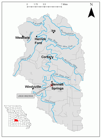
Bennett Spring is located in Dallas County inside Bennett Spring State Park, in Missouri’s Ozark Highlands Section. The spring is named after the Bennett family, who built a mill at the spring during the Civil War. Bennett Spring State Park is now one of Missouri’s oldest and most popular state parks, and the streamgage has been in operation for 91 years.
The streamgage is located about 300 feet below the outflow of Bennett Spring in Dallas County and consists of an old gage house, a new shelter, a data collection platform, an electronic pressure transducer to measure stage and a staff gage attached to the old gage house used to manually verify stages. Learn how a USGS streamgage works.
Streamgage Information
• Aquifer Name: Ozark Plateaus aquifer system
• 10-Digit Hydrologic Unit Code: 1029011002
• Area of HUC10 Basin: 232 square miles
• Gage Location: 37°43'01.73", -92°51'27.26" (Dallas County)
• Gage Datum: 864.71 feet above NGVD29
USGS Tools
- Average Discharge (cubic feet per second): Oct. 1, 1928 to present
- Observation Gage Height (feet): Feb. 9, 2007 to present
- Peak: Gage Height, Discharge (feet, cubic feet per second) 10.55, 12,600 (Dec. 27, 2015, May 25, 1990)
The Bennett Spring streamgage webpage is maintained by USGS. Users are able to create graphs and tables utilizing the recorded parameters, which can be customized to show current and historical observations, daily data, daily statistics, monthly statistics, annual statistics, peak streamflow, water quality samples and field measurements for any time frame within the period of record. A location map and Water-Year Summary also are available. Customize your own data output online.https://waterdata.usgs.gov/monitoring-location/06923500.
Why is the Bennett Spring Streamgage Important?
The streamgage provides recreational users in the area, surrounding landowners and the public with accurate stream height and spring discharge data. The Water Resources Center uses discharge data from this streamgage for flood, drought and water supply studies.
In the area, people can enjoy:
- Bird-watching
- Tours
- Camping
- Hunting
- Fishing and Fly-fishing
- Floating and Canoeing
For more information about recreation activities located within the basin, contact the Missouri Department of Conservation.
P1010511.jpg
Figure 3. Staff gage on side of old gage house.
P1010519.jpg
Figure 4. Site profile.
P1010506.jpg
Figure 5. Bennett Spring.
P1010508.jpg
Figure 6. Spring Branch.
Nothing in this document may be used to implement any enforcement action or levy any penalty unless promulgated by rule under chapter 536 or authorized by statute.
For more information
Water Resources Center - Jefferson City
Missouri Geological Survey
P.O. Box 176
Jefferson City, MO 65102-0176
United States