Missouri Geological Survey Director: Carey Bridges, RG
The South Grand River streamgage at Archie is owned by the U.S. Geological Survey (USGS) and funded in cooperation with the Missouri Department of Natural Resources. Stage (water-surface elevation) measurements are made and recorded at 15-minute intervals and transmitted to the USGS office every hour. Stage and streamflow values are displayed in near real-time.
The South Grand River is a stream in Missouri’s Scarped Osage Plains Subsection of the Osage Plains, flowing into Harry S Truman Reservoir. It is believed to be named after the Grand River in Northwest Missouri, though the two rivers do not meet.
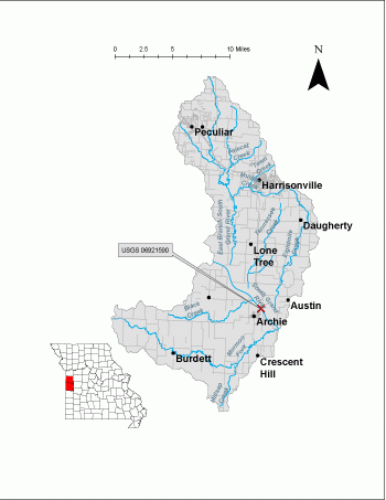
The streamgage is located at the SW Outer Road/Old US Hwy 71 bridge over the South Grand River north of Archie in Cass County and consists of a shelter, a data collection platform, a rain gage, an electronic pressure transducer to measure stage, a crest stage gage (Figure 3) to automatically record crest height during high water events and a wire weight gage to manually verify electronic measurements. Learn how a USGS streamgage works.
Streamgage Information
- Streamgage Drainage Area: 356 square miles
- 10-Digit Hydrologic Unit Code: 1029010802
- Area of HUC10 Basin: 226 square miles
- Gage Location: 38°29’29.69”, -94°20’39.28” (Cass County)
- Gage Datum: 767 feet above NAVD88
USGS Tools
- Average Discharge (cubic feet per second): Oct. 1, 1969 to Sept. 30, 1986, and June 1, 2007 to present
- Observation Gage Height (feet): Sept. 30, 2007 to present
- Peak: Gage Height, Discharge (feet, cubic feet per second) 28.51, 34,700 (July 1, 2007)
The South Grand River at Archie streamgage webpage is maintained by USGS. Users are able to create graphs and tables utilizing the recorded parameters, which can be customized to show current and historical observations, daily data, daily statistics, monthly statistics, annual statistics, peak streamflow and field measurements for any time frame within the period of record. A location map and Water-Year Summary also are available. Customize your own data output online.
Why is the South Grand River Streamgage at Archie Important?
The streamgage provides recreational users in the area, surrounding landowners and the public with accurate stream height data. The Water Resources Center uses discharge data from this streamgage for flood, drought and water supply studies. The river is a major inflow to the Truman Reservoir.
In the area, people can enjoy:
- Bird-watching
- Camping
- Fishing
- Floating
- Horseback riding
- Hiking
- Motor boating
- Field Trials (Canine sport)
For more information about recreation activities located within the basin, contact the Missouri Department of Conservation.
P1010499.jpg
Figure 3. Crest Stage Gage attached to a tree.
P1010501.jpg
Figure 4. Cross section view of bridge and stream.
P1010494.jpg
Figure 5. Side view of streamgage.
Nothing in this document may be used to implement any enforcement action or levy any penalty unless promulgated by rule under chapter 536 or authorized by statute.
For more information
Water Resources Center - Jefferson City
Missouri Geological Survey
P.O. Box 176
Jefferson City, MO 65102-0176
United States