Missouri Geological Survey Director: Carey Bridges, RG
The Weaubleau Creek streamgage near Weaubleau is owned by the U.S. Geological Survey (USGS) and funded in cooperation with the Missouri Department of Natural Resources. Stage (water-surface elevation) measurements are made and recorded at 15-minute intervals and transmitted to the USGS office every hour. Stage and streamflow values are displayed in near real-time.
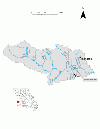
Weaubleau Creek is a stream in Missouri’s Ozark Highlands, flowing into Harry S Truman Reservoir. It is unknown where the name came from but has been marked as Wablo and Weablo on historical maps. The river was marked as the Lime River on a map in 1806.
The streamgage is located at the State Highway 54 bridge over Weaubleau Creek near Weaubleau in Hickory County and consists of a shelter, a data collection platform, an electronic pressure transducer to measure stage, a crest stage gage to automatically record crest height during high water events and a wire weight gage to manually verify the electronic measurements. Learn how a USGS streamgage works.
Streamgage Information
- Streamgage Drainage Area: 37.8 square miles
- 10-Digit Hydrologic Unit Code: 1029010503
- Area of HUC10 Basin: 139 square miles
- Gage Location: 37°53’43.77”, -93°30’53.14” (Hickory County)
- Gage Datum: 839 feet above NAVD88
USGS Tools
- Average Discharge (cubic feet per second): March 28, 2012 to present
- Observation Gage Height (feet): March 28, 2012 to present
- Peak: Gage Height, Discharge (feet, cubic feet per second) 15.92, 14,600 (July 2, 2015)
The Weaubleau Creek near Weaubleau streamgage webpage is maintained by USGS. Users are able to create graphs and tables utilizing the recorded parameters, which can be customized to show current and historical observations, daily data, daily statistics, monthly statistics, annual statistics, peak streamflow and field measurements for any time frame within the period of record. A location map and Water-Year Summary also are available. Customize your own data output online.
Why is the Weaubleau Creek Streamgage near Weaubleau Important?
The streamgage provides recreational users in the area, surrounding landowners and the public with accurate stream height data. The Water Resources Center uses discharge data from this streamgage for flood, drought and water supply studies. Due to the streamgage drainage area being 38 square miles, the gage was installed to help monitor drought in the stream headwaters.
In the area, people can enjoy:
- Bird-watching
- Camping
- Fishing
- Floating
- Horseback riding
- Hiking
- Hunting
- Waterfowl hunting
- Trapping
For more information about recreation activities located within the basin, contact the Missouri Department of Conservation.
P1010472.jpg
Figure 3. Bent Crest Stage Gage.
P1010473.jpg
Figure 4. Cross Section of Stream.
P1010481.jpg
Figure 5. Alternative view of streamgage.
1 References Cited
Overlay, Fauna R. "Place Names Of Five South Central Counties Of Missouri." M.A. thesis., University of Missouri-Columbia, 1943.
Nothing in this document may be used to implement any enforcement action or levy any penalty unless promulgated by rule under chapter 536 or authorized by statute.