Missouri Geological Survey Director: Carey Bridges, RG
The Medicine Creek streamgage near Laredo is owned by the U.S. Geological Survey (USGS) and funded in cooperation with the Missouri Department of Natural Resources. Stage (water-surface elevation) measurements are made and recorded at 15-minute intervals and transmitted to the USGS office every hour. Stage and streamflow values are displayed in near real-time.
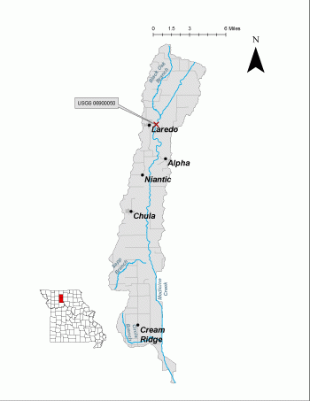
Medicine Creek is a stream in Missouri’s Grand River Hills Subsection of the Central Dissected Till Plains, flowing into the Grand River. The stream is believed to be named after the medicinal herbs found along the stream used by Native Americans (Adams).
The streamgage is located at the State Highway E bridge over Medicine Creek east of Laredo in Grundy County and consists of a shelter, a data collection platform, a rain gage, an electronic pressure transducer to measure stage a crest stage gage to automatically record crest height during high water events and a wire weight gage used to manually verify electronic measurements. Learn how a USGS streamgage works.
Streamgage Information
- Streamgage Drainage Area: 355 square miles
- 10-Digit Hydrologic Unit Code: 1028010303
- Area of HUC10 Basin: 87.1square miles
- Gage Location: 40°01’35.8” ,-93°26’10.4” (Grundy County)
- Gage Datum: 739 feet above NAV88.
USGS Tools
- Average Discharge (cubic feet per second): Nov. 14, 2000 to present
- Observation Gage Height (feet): Oct. 1, 2000 to present
- Peak: Gage Height, Discharge (feet, cubic feet per second) 21.76, 23,800 (May 16, 2009)
The Medicine Creek near Laredo streamgage webpage is maintained by USGS. Users are able to create graphs and tables utilizing the recorded parameters, which can be customized to show current and historical observations, daily data, daily statistics, monthly statistics, annual statistics, peak streamflow and field measurements for any time frame within the period of record. A location map and Water-Year Summary also are available. Customize your own data output online.
Why is the Medicine Creek Streamgage near Laredo Important?
The streamgage provides recreational users in the area, surrounding landowners and the public with accurate stream height data. The Water Resources Center uses discharge data from this streamgage for flood, drought and water supply studies.
In the area, people can enjoy:
- Bird-watching
- Hunting
- Fishing
- Shooting ranges
For more information about recreation activities located within the basin, contact the Missouri Department of Conservation.
P1010792.jpg
Figure 3. Profile of stream.
P1010793.jpg
Figure 4. Downstream view.
1 References Cited
Adams, Orvyl Guy. "Place Names In The North Central Counties Of Missouri." M.A. thesis., University of Missouri-Columbia, 1928.
Nothing in this document may be used to implement any enforcement action or levy any penalty unless promulgated by rule under chapter 536 or authorized by statute.
For more information
Water Resources Center - Jefferson City
Missouri Geological Survey
P.O. Box 176
Jefferson City, MO 65102-0176
United States