Missouri Geological Survey Director: Carey Bridges, RG
The Crooked River streamgage near Richmond is owned by the U.S. Geological Survey (USGS) and funded in cooperation with the Missouri Department of Natural Resources. Stage (water-surface elevation) measurements are made and recorded at 15-minute intervals and transmitted to the USGS office every hour. Stage and streamflow values are displayed in near real-time.
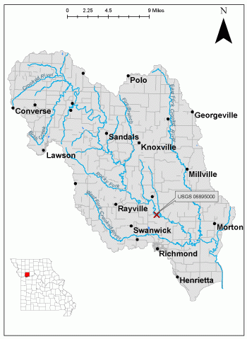
The Crooked River, named for its sinuosity, is located east of Kansas City, Missouri, and flows through the Central Dissected Till Plains. The basin overlies the Lexington Coal Field (MDC). The Crooked River is locally known as Big Creek due to its size as the largest stream in Ray County (Eaton).
The streamgage is located at the State Route 13 bridge over Crooked River, four miles north of Richmond in Ray County and consists of a shelter, a data collection platform, an electronic pressure transducer to measure stage, a crest stage gage (Figure 5) to automatically record crest height during high water events and a wire weight gage (Figure 6) used to manually verify electronic measurements. Learn how a USGS streamgage works.
Streamgage Information
- Streamgage Drainage Area: 159 square miles
- 10-Digit Hydrologic Unit Code: 1030010107
- Area of HUC10 Basin: 350 square miles
- Gage Location: 39°19'57.59", -93°58'48" (Ray County)
- Gage Datum: 706.34 feet above NAVD88
USGS Tools
- Average Discharge (cubic feet per second): March 1, 1948 to present
- Observation Gage Height (feet): Sept. 30, 2007 to present
- Peak: Gage Height, Discharge (feet, cubic feet per second) 30.7, 29,000 (July 20, 1965)
The Crooked River near Richmond streamgage webpage is maintained by USGS. Users are able to create graphs and tables utilizing the recorded parameters (discharge and gage height) which can be customized to show current/historical observations, daily data, daily statistics, monthly statistics, annual statistics, peak streamflow, water quality, and field measurements for any time frame within the period of record. A location map and Water-Year Summary are also available. Customize your own data output.
Why is the Crooked River Streamgage near Richmond Important?
The streamgage provides recreational users in the area, surrounding landowners and the public with accurate stream height data. This streamgage was installed due to the flashy character of the river and to fill a gap in the USGS water dataset. Winter flow is affected by ice. The Water Resources Center uses discharge data from this streamgage for flood, drought and water supply studies. The National Oceanic and Atmospheric Administration publishes a standalone forecast for this streamgage during times of high water.
A majority of the land within the Crooked River basin is privately owned, with population and development increasing in the area due to the growth of nearby Kansas City (MDC). The stream corridor is lined by trees and agriculture fields surround the streamgage.
In the area, people can enjoy:
- Fishing
- Hunting
- Bird-watching
- Camping
- Hiking
- Boating and Floating
For more information on recreation activities located within the basin, contact the Missouri Department of Conservation.
Figure 3. Cross section view of site.
Figure 4. Upstream view of river.
Figure 5. View of the crest stage gage.
Figure 6. View of the wire weight gage.
1 REFERENCES CITED
Crooked River - Missouri Department of Conservation
Eaton, David Wolfe (1917). How Missouri Counties, Towns and Streams Were Named. The State Historical Society of Missouri. p. 346.
Nothing in this document may be used to implement any enforcement action or levy any penalty unless promulgated by rule under chapter 536 or authorized by statute.
For more information
Water Resources Center - Jefferson City
Missouri Geological Survey
P.O. Box 176
Jefferson City, MO 65102-0176
United States