Missouri Geological Survey Director: Carey Bridges, RG
The One Hundred and Two River near Bolckow is owned by the U.S. Geological Survey (USGS) and funded in cooperation with the Missouri Department of Natural Resources. Stage (water-surface elevation) measurements are made and recorded at 15-minute intervals and transmitted to the USGS office every hour. Stage and streamflow values are displayed in near real-time.
The One Hundred and Two River originates in southern Iowa and passes through the Missouri Central Dissected Till Plains of Nodaway, Andrew and Buchanan counties before emptying into the Platte River. The origin of the name is uncertain but may be derived from French explorers’ corruption of an Osage name into “Rivière Cent Deux,” translated into English as One Hundred and Two River. An alternate theory suggests the river was named for its supposed length by explorers in 1823, despite the river only being 80 miles long (Maryville).
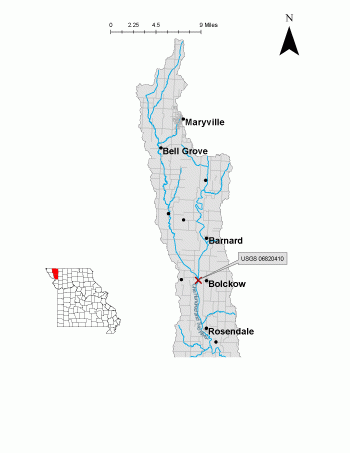
The streamgage is located on the lower reach of the One Hundred and Two River at the State Highway B Bridge near Bolckow in Andrew County and consists of a shelter, a data collection platform, rain gage, a radar stage sensor and a crest stage gage to automatically record crest height during high water events. Learn how a USGS streamgage works.
Streamgage Information
- Streamgage Drainage Area: 646.8 square miles
- 10-Digit Hydrologic Unit Code: 1024001304
- Area of HUC10 Basin: 246 square miles
- Gage Location: 40°06'49", 94°50'18" (Andrew County)
- Gage Datum: 917 feet above NAVD88
USGS Tools
- Preciptiation (inches): March 28, 2019 to present
- Average Discharge (cubic feet per second): Feb. 28, 2008 to present
- Observation Gage Height (feet): Feb. 28, 2009 to present
- Peak: Gage Height, Discharge (feet, cubic feet per second) 23.32, 31,400 (Sept. 10, 2014)
The One Hundred and Two River near Bolckow streamgage webpage is maintained by USGS. Users are able to create graphs and tables utilizing the recorded parameters, which can be customized to show current and historical observations, daily data, daily statistics, monthly statistics, annual statistics, peak streamflow and field measurements for any time frame within the period of record. A location map and Water-Year Summary also are available. Customize your own data output online. https://waterdata.usgs.gov/monitoring-location
Why is the One Hundred and Two River Streamgage near Bolckow Important?
The streamgage provides recreational users in the area, surrounding landowners and the public with accurate stream height data. Gage height is affected by ice during the winter months. The data collected is also valuable for understanding hydrologic conditions in Andrew County. The Water Resources Center uses discharge data from this streamgage for flood, drought and water supply studies. This streamgage has 132 more square miles of catchment area than the One Hundred and Two Streamgage at Maryville, making it important for determining discharge due to stormwater.
The One Hundred and Two River and its tributaries are important for recreation and wildlife conservation interests (MDC). The river is designated as a Class I(II) rapid that provides recreational boating to the area and nature photography opportunities (Whitewater).
In the area, people can enjoy:
- Bird-watching
- Camping
- Fishing
- Hunting
- Hiking
- Boating and Floating
For more information about recreation activities located within the basin, contact the Missouri Department of Conservation.
Figure 3. Stream topography.
Figure 4. Instrumentation on bridge parapet.
Figure 5. Bridge detail after major flood event.
Figure 6. Cross section view of bridge and stream
1 REFERENCES CITED
American Whitewater (May 2019). One Hundred and Two (102) Maryville to St. Joseph
Missouri Department of Conservation (June 2019). Nodaway County Community Lake
Nothing in this document may be used to implement any enforcement action or levy any penalty unless promulgated by rule under chapter 536 or authorized by statute.
For more information
Water Resources Center - Jefferson City
Missouri Geological Survey
P.O. Box 176
Jefferson City, MO 65102-0176
United States